
Survey
name: Solsikke/Havsule & Ormen Lange (MCSBL-SH-02/MCSBL-OL-02)
Survey type: Non-Exclusive MCSBL survey
Survey size: Solsikke/Havsule & Ormen Lange
Data is available


INTRODUCTION
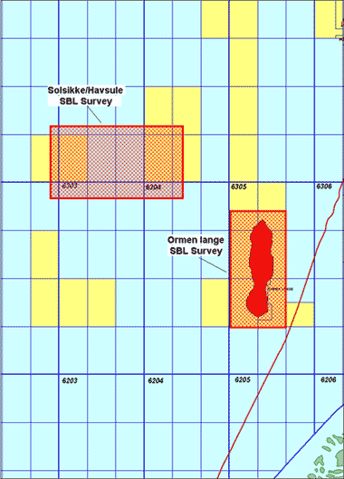
In December 2002, InSeis Terra and emgs completed the 1st common non-exclusive
multi client Sea-Bed-Logging (SBL) survey. SBL is the newly developed direct
hydrocarbon indicator method, that utilizes electromagnetic waves to verify
if a reservoir contains hydrocarbons or not.
The survey was partly pre-financed by the oil & gas industry and was conducted
during October and November 2002 in the Solsikke/Havsule and Ormen Lange areas.
This survey will provide the industry with a unique SBL dataset acquired over
the open Block 6403/11 and Block 6403/12 as well as over the Solsikke PL 251
license in Block 6403/9 and Block 6403/10 (tying in well 6403/10-1) and over
the Havsule PL 254 license in Block 6404/11 (tying in well 6404/11-1). A SBL
reference survey was also acquired over the Ormen Lange field and made available
to the participating oil companies.
Multiwave Geophysical Companysvessel R/V Polarbjørn conducted the survey
using the new emgs ElectroMagnetic source with a controllable dipole antenna
and crossed electrical MMT-24 format dipole receivers. The separation between
the receivers was approx. 1,000 m while recording was done continuously. Processed
and interpreted data is available.
SEA BED LOGGING
The SBL method is a remote sensing technique using a mobile electromagnetic
source and an array of seafloor electric field receivers to measure resistivity.
The source emits a low frequency electromagnetic signal that is affected by
buried resistive layers (e.g. hydrocarbon reservoirs). The reservoirs’
effect can be observed in the signal registered by the receivers.
While seismic surveying is based on sound waves and a proven method of defining
structures and identifying possible reservoirs, SBL is based on electromagnetic
waves and can define whether the reservoir contains hydrocarbons or water. As
a result, the two technologies are complementary in the exploration phase.
By running a SBL survey the oil companies can significantly increase the probability
of making a correct evaluation of the fluid content of a reservoir as defined
by seismic. The SBL method will enable prospects to be ranged with increased
confidence and should substantially reduce the number of dry wells.
A full size field test was carried out over the Girassol and Dalia fields, offshore
Angola in November 2000. The results were very successful and the processed
field data show that the SBL concept is sensitive to buried high resistive layers
and will, under such conditions, act as a direct hydrocarbon detection method.
ElectoMagnetic GeoServices (emgs), who has developed this technology, is an
independent market player. emgs’ core area of focus is to plan, acquire,
process and interpret SBL surveys, and the services provided by emgs will provide
oil companies with an additional valuable source of information with regard
to oil and gas exploration and increase the probability of detecting hydrocarbons
in deep-water areas. InSeis Terra has entered into an agreement with emgs, giving
InSeis Terra the exclusive right to provide multi-client and group SBL surveys.
GEOLOGICAL SUMMARY
The proposed MC-SBL-2002 survey will cover open acreage west of the
Havsule license (PL 254) and east of the Solsikke license (PL 251) and includes
also the southern extension of the Slettringen Lineament. The faults are generally
striking towards northeast, following the Kimmeridgian (Upper Jurassic-Lower
Cretaceous) extension. There are also lineaments perpendicular to this direction
in the area, for example the Jan Mayen Lineament striking NNW-SSE located just
north of the proposed survey area. A large inversion structure is present, mainly
in block 6403/12, and the interpretation of the existing HW-2001 2D data in
the area, that has been carried out by InSeis Terra, reveals that large closures
are formed at Tertiary and Cretaceous levels.
High-amplitude events appear relatively frequent at an internal Cretaceous reflector
(poss. Top Lysing) at approximately 4.0 seconds twt and seem to coincide with
the spill-level. The existing 2D seismic also shows some flat events with high
amplitudes that are observed at the top structure.
The MCSBL survey with its ties to well 6404/11-1 (Havsule) and well 6403/10-1
(Solsikke) will be very useful in order to evaluate potential reservoir properties
as well as to provide valuable information about the fluid content and degree
of fill.
The water depth varies between 1,400 m - 1,600 m in the Solsikke/Havsule area
and 800 m - 900 m in the Ormen Lange area, and this survey will provide oil
companies with a unique SBL data set that can be very important in order to
evaluate results from other SBL surveys over prospects in deepwater Mid-Norway.

Nordkapp Basin - Helgeland Basin - Røsthøgda West - Jan Mayen Ridge - Havsule West - Vøring - Faroe