UAV Documentation
Weekly Meeting Notes (Google Doc)
Data
| Data type | Includes | macOS path | Windows path |
|---|---|---|---|
| Raw data | Original UAV mission data | smb://atlas.shore.mbari.org/UAV | cifs://atlas.shore.mbari.org/UAV |
| Processed data | Processed outputs, including cluster grids | smb://atlas.shore.mbari.org/UAV/machineLearning | cifs://atlas.shore.mbari.org/UAV/machineLearning |
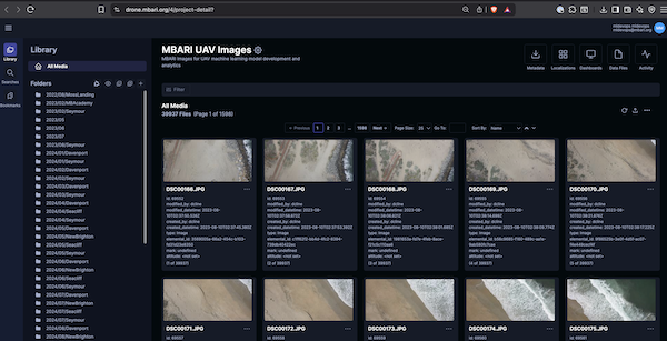
Image and results will be available in Tator tool at drone.mbari.org. In this tool, a user can click on an image and see the image preview, and the metadata associated with that image such as the camera type, location, and time the picture was taken, or browse the localizations that were detected in the image.
Note about guest access
A read-only account is available to preview the images and data products in the browser. Username: guest, password: mbariguest.
The current data management workflow is as follows:
QBase processing
Trinity F90+ QBase3D processing workflow This Google doc describes specific procedures and settings to be used when processing Trinity flight data first with QBase3D then further processed with MBARI’s UAV processing software. Note that QBase3D is a Windows application. The MBARI UAV software is implemented in python 3, so can in principle be executed on various operating systems. However, we have only tested and used the MBARI software on linux operating systems, ubuntu specifically. Therefore, this document assumes the MBARI software is run on ubuntu. This is typically done on the laptop that is used to control the UAV.
Image collection and Level processing
The UAV has a mission, data is collected and stored on the UAV, downloaded then processed on shore by the UAV team (Tom O'Reilly) into Level-0, Level-1, and Level-2 data products.
- Level-0 - Raw data from the UAV
- Level-1 - Data products that are derived from the raw data that include time, location, and other metadata
- Level-2 - Data products that are derived from Level-1 data products that are converted to GeoTiFFs, and warped to orthographic projections
The code for processing data is available at https://bitbucket.org/mbari/uavprocessing/

Mission processing
The Google spreadsheet has notes on the processing status of each mission. The is maintained by D.Cline but any member of the UAV team can add to it. This will process the level images, ftp them to Axiom servers, load them into the Tator database, and run the AI pipeline.The AI pipeline detects objects of interest, classifies, and clusters them.
ssh uavshared@uav.shore.mbari.org
then run the following command
just pull-from-share trinity-2_20250410T182611_Monterey
just process-l1-l2 trinity-2_20250410T182611_Monterey
just process-ai trinity-2_20250410T182611_Monterey
Images are processed by an AI pipeline to assist with data annotation and exploration.
More detail on the AI tools used can be found in the MBARI AI documentation.

Batch processing missions
Batch processing happens with a simple .txt file called missions.txt in the same directory as the code.
For example, if you want to batch load the images from the mission trinity-3_20260318T170157_Seymour
and trinity-3_20260417T174030_Davenport, add that to the missions.txt file.
# cuda device id, mission_name, mission_dir, section, start_image(optional), end_image(optional)
cuda:0,/mnt/uav/Level-1/trinity-3_20260318T170157_Seymour/SONY_ILX-LR1,2026/04/Seymour,,
cuda:0,/mnt/uav/Level-1/trinity-3_20260417T174030_Davenport/SONY_ILX-LR1,2026/04/Davenport,,
Comments
Lines with # are ignored. This can useful to comment out lines that you don't want to process, or as used
above to explain the file format.
Loading images with:
just load-images
Run the entire pipeline, load, detect, classify with:
just process-ai-missions
updated: 2026-04-20