Stations
The 'Layers' dropdown includes a Stations entry that allows to define, update, and select generic "points" to be displayed on the map.
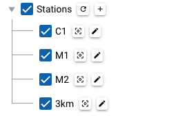
Operators have the ability to define and update the stations list, which is maintained in the backend.
-
Use the
+button to add a new station.
A station will be initialized at the center of the map to facilitate further editing. -
Use the
editbutton to modify or delete a station.
Note for operators
These definitions are shared for all users, so please keep this in mind when updating or deleting entries.
Each station is defined in terms of a given name and a GeoJSON Feature, whose associated geometry is expected to be a GeoJSON Point.
For example, the GeoJSON feature associated to the traditional "C1" station is defined as follows:
{
  "type": "Feature",
  "properties": {
    "color": "yellow"
  },
  "geometry": {
    "type": "Point",
    "coordinates": [
      -121.847,
      36.797
    ]
  }
}
Note
- The editing itself is performed by adjusting the GeoJSON text directly.
- Some basic checks are in place, but no strict validation is performed.
- Settings under the
propertiessection can be used to customize some display attributes. - In GeoJSON, the elements of a Position are in the order longitude, then latitude (both using decimal numbers).
- You may find GeoJSON online editors like the following useful: