Noteworthy frontend changes
The backend change log is here.
4.99
4.99.36 (2026-07-24)
-
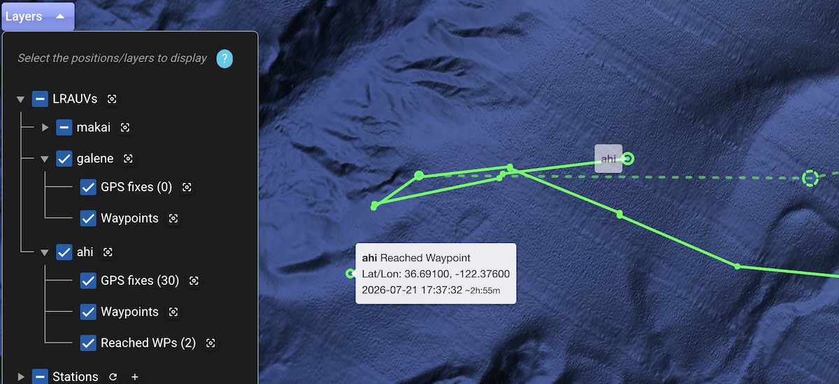
Adjustments in handling/parsing of reached-waypoint events to fix a long unnoticed regression that manifested by such waypoints not getting displayed on the map.
- The primary adjustment done in the dash backend for the corresponding API.
- Complementary adjustment done in dash4 to also recognize such events when reported asynchronously.
-
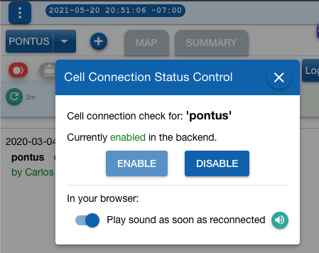
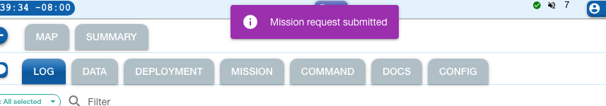
Cell connection status dialog now with a close button to facilitate closing it on a small screen.
4.99.35 (2026-07-20)
For traditional authentication system:*
-
Token expiration is now properly handled. The handling now terminates the (expired) session, takes the UI to the Log tab if it was on an operator-only tab, and shows a modal dialog informing the user about the expired session and need to sign in again.
-
The unnecessary sign-out confirmation dialog has been removed.
* These adjustments are not relevant to Dash4 instances configured (including corresponding support in TethysDash backend) with the different authentication system implemented in early 2025, which the MBARI Dash4 instance uses.
4.99.34 (2026-07-06)
New verification code step when adding/editing notification recipient.
This is the dash4 counterpart of such new feature implemented in backend 4.99.85.
When adding or editing a recipient:
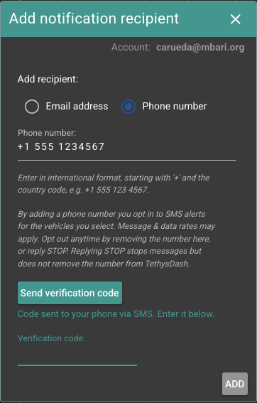
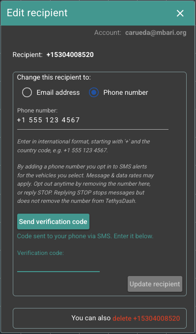
These two dialogs now also include:
- A button to send verification code to the intended recipient (SMS text or email). The generated code is valid for 10 minutes.
- A field where the user then enters the received code.
- Rest of the interaction as usual.
Why this step matters
This is the same standard "confirm your email/phone" step used by most services. It ensures the address is entered correctly and can actually receive notifications. A recipient that looks fine in the settings but has a small typo would silently receive nothing. Requiring a code confirms the address works before you rely on it.
4.99.33 (2026-06-24)
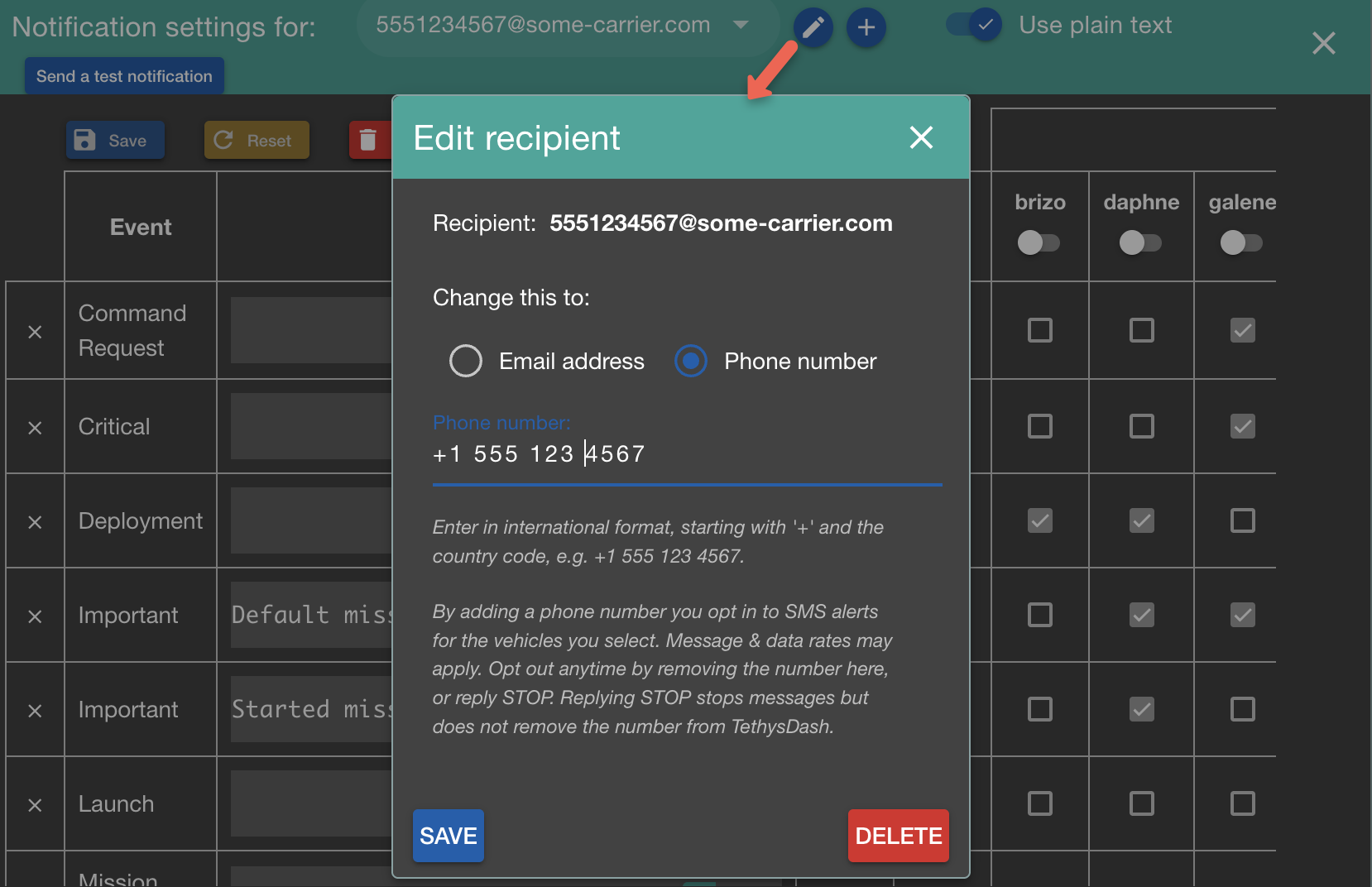
- Admin interface: The 'Notifications settings' dialog now includes a filter, which greatly helps select the desired entries for inspection and any edits. (Thanks, Fred B., as your recent inquiry reminded me about this long-standing todo ;)
4.99.32 (2026-06-15)
-
Notifications: SMS provider has approved production access so phone numbers can now be indicated as notification destinations. For now, we consider this a beta release while the feature gets to be exercised for some time, possibly involving backend and AWS account setup adjustments, etc. Please see experimental/sms.
-
Mission tab: More visible link to mission documentation.
4.99.31 (2026-06-08)
-
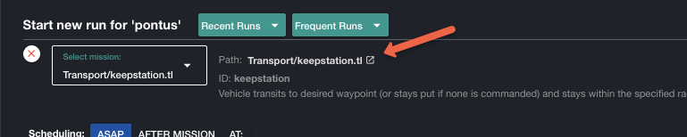
Mission parameters setup: When using Re-run or selecting from Recent/Frequent Runs, a value/unit swap is now performed for each string argument. For example, from
value=string,unit="02_roll"tovalue="02_roll",unit=none_str. This was a pending adjustment upon the initial support on the LRAUV for string parameters, which requires the specialstringkeyword before the value to recognize it as such.
4.99.30 (2026-06-06)
-
Command handling fixes regarding quotes (
") in string values.- Any (unescaped) quote in the command itself is now escaped:
\". - This handling includes the "preview" feature as well.
- Note: scheduling information is handled separately when submitting the
request to the backend:
Any quote there (e.g.,
sched asap "...") remains unescaped.
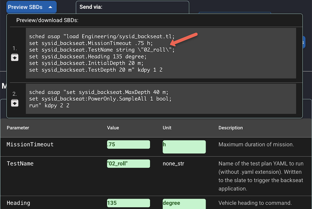
The multiple command feature is the exception
Each chunk is assumed to be a fully-formed command payload, including any escaped nested strings.
Thanks, Quinn S., for bringing up the need for these adjustments as the support for string values is also advanced on the LRAUV side.
- Any (unescaped) quote in the command itself is now escaped:
-
Basic preparations for notifications via SMS.
4.99.22 (2026-06-02)
-
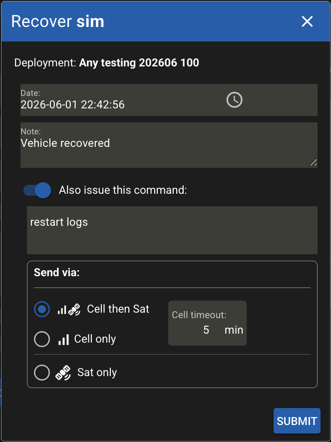
Deployment: The launch/recover dialog now includes the send-via and timeout settings. Previously, these were fixed to cell-then-sat with 5-min cell timeout.
4.99.21 (2026-05-22)
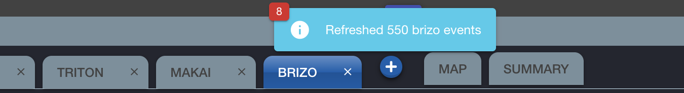
-
Instead of stacking multiple popup notifications when refreshing events in rapid sequence, now only one is displayed, with the little badge showing the number of vehicles refreshed. Thanks, Steve H., for the suggestion.
-
Adjustments/fixes in the display of tracking DB assets. (An issue with a time window limit was noted while monitoring a patch tracking exercise performed by a wave glider.)
4.99.2 (2026-05-18)
- The connection for asynchronous notifications now uses a more secure endpoint recently implemented in the backend server.
4.99.1 (2026-05-14)
- Interim opt-in mechanism for testing new
/wsendpoint.
4.99.0 (2026-04-28)
- Dash4 is being deprecated now. See https://okeanids.mbari.org/home/.
4.98
4.98.9 (2026-04-27)
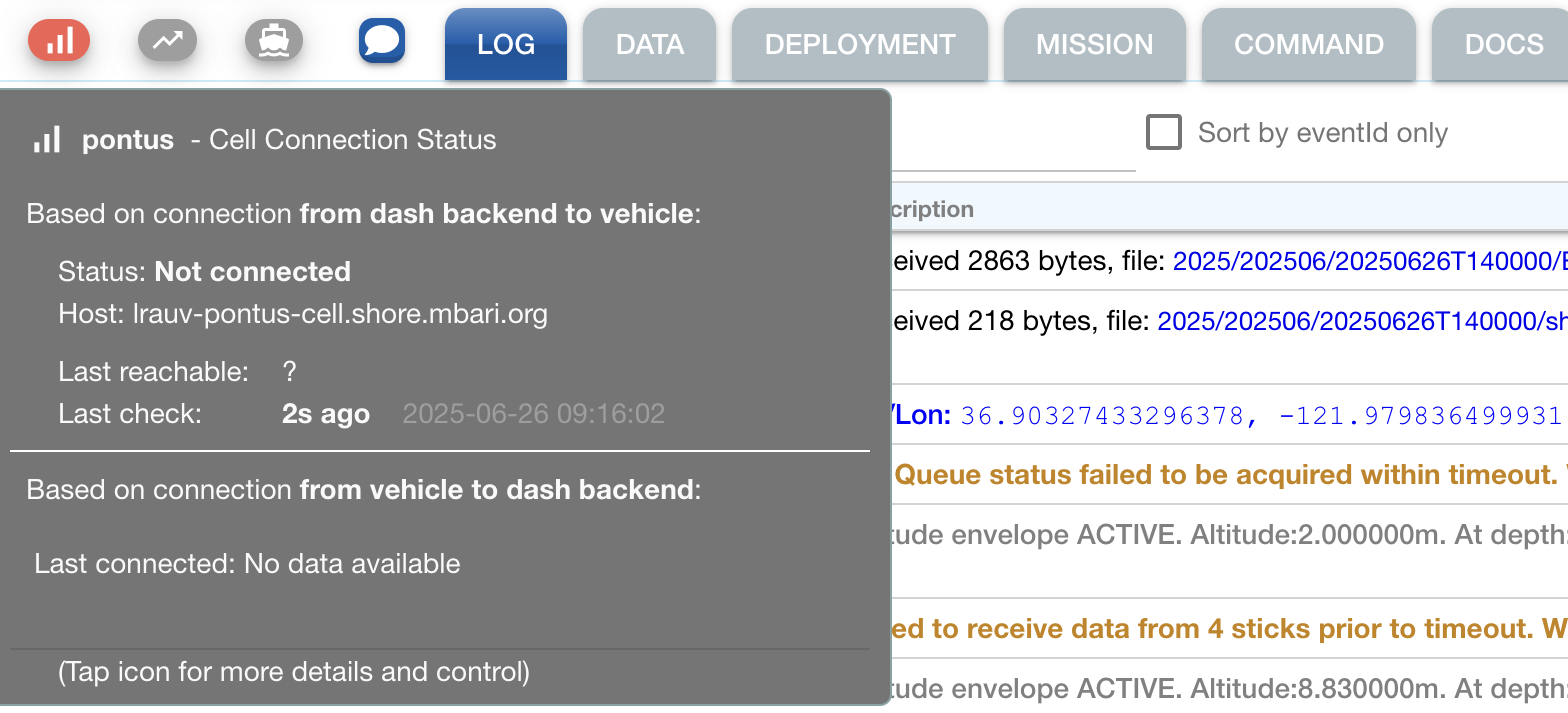
- Based on a revised API endpoint in the backend, the tooltip/dialog associated to the cell connection status button now also displays a recent vehicle ping history.
4.98.8 (2026-04-21)
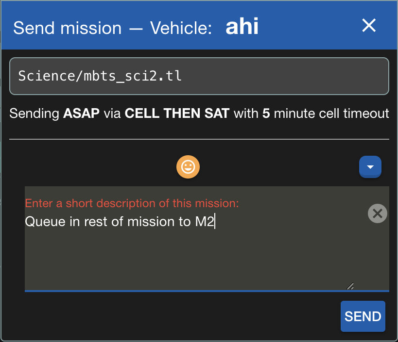
-
Mission tab: The confirmation dialog for submission now also shows a summary in terms of the mission filename and the scheduling and send-via settings:
-
Command and Mission tabs: As intended, all settings are now back to their default values upon submission of the command or mission. Thanks, Monique, for reporting this issue.
4.98.7 (2026-04-13)
-
TrackingDB assets can now be starred ⭐.
- Click the star icon next to an asset to star or unstar it
- Starred assets appear first within their category
- Use the 'Only show starred' checkbox to filter to starred assets only
-
Note: Stars are saved in browser local storage (not synced across devices)
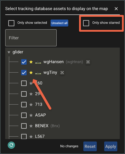
Thanks, Steve H., for the suggestion.
4.98.6 (2026-03-17)
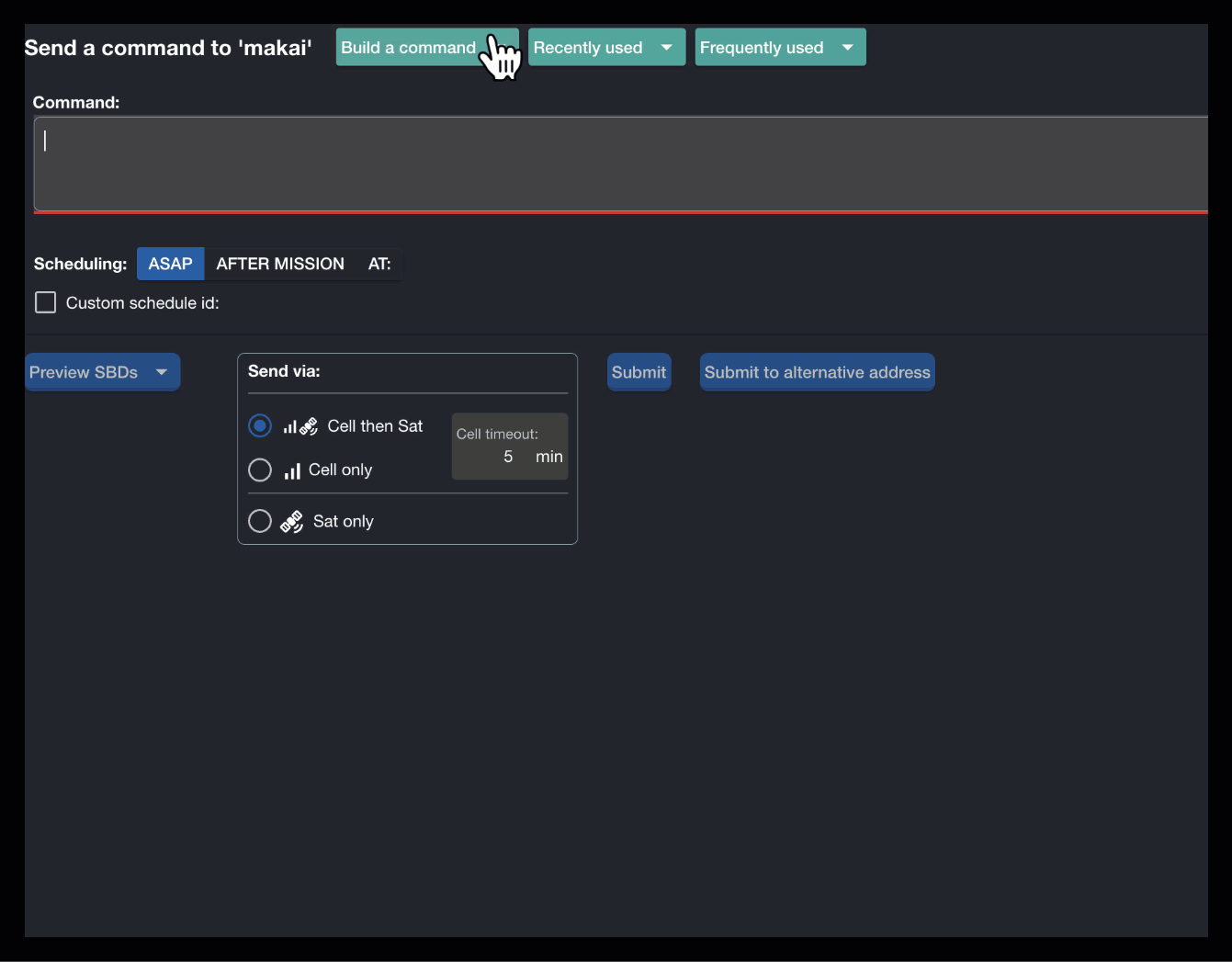
- Command tab:
- Fixed a bug in the 'Build a command' dispatch: for syntaxes involving a Mission Uri variable type, once a mission is selected, the Element: dropdown list would only include its top-level arguments. Now, the arguments corresponding to all inserts are also included.
-
Usability improvements:
- Now allowing filtering in various command build related dropdowns, for example, in the Element: dropdown list.
- Color adjustment in various labels for better legibility (in particular, for when in dark mode).
4.98.5 (2026-03-09)
- Internal logging adjustment/fix in the PIC/On-Call Operators dropdown. (Done while investigating backend regression that was then fixed.)
4.98.4 (2026-03-02)
MBARI instance note
A discrepancy of ~31 seconds was observed in production (2026-02-28)
between the TethysDash backend server (tethsydash2) system time
and Firebase authentication token issuer,
causing newly issued tokens to be rejected as "not yet valid"
(nbf claim violation),
which manifested as users being unexpectedly signed out on the Dash4 UI.
The cause (as later on confirmed by IS) was transient VM clock drift.
To guard against this, a 60-second leeway was added to token validation.
As Firebase tokens last 1 hour, the 60s is a safe margin.
(Adjustment done in the backend but mentioned here for visibility.)
- Adjustment in retry logic for request to the backend upon authentication issue. Recent changes in the backend include more consistent use of response codes, with 401 for invalid or expired token, instead of 403. This is still under revision for the backend, so, for now, the retry logic in the UI is triggered for both 401 and 403 (this one to be removed in the future).
4.98.3 (2026-02-23)
- Minor adjustments while testing modernized TethysDash API endpoints. No functionality/visible changes in the dash4 UI per se.
4.98.2 (2026-01-30)
-
Mission tab: When the value of an overwritten mission argument is a string literal, and the associated unit is either
none_stror not given, then the corresponding command is now generated with syntax supported by the LRAUV as:instead of:set missionID.ArgName string "the value";set missionID.ArgName "the value" n/a str;`Example:
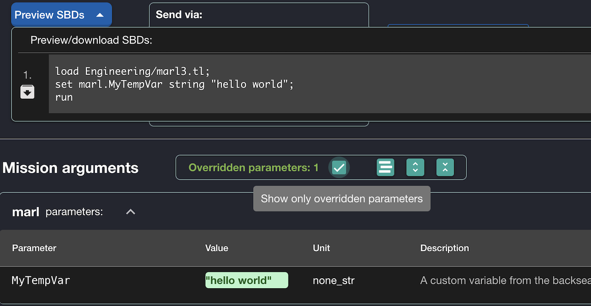
This is part of adjustments also involving the new ability in TethysL to define mission arguments with a string literal initialization, for example:
 mission {
   arguments {
     SomeArg = "init"
   }
 }
4.98.1 (2026-01-28)
- Map tab: The 'ESRI Oceans/Labels' base map layer option is now included even when there's no ESRI Api key provided in configuration. In this case, the previous ESRI mechanism is used.
4.98.0 (2026-01-22)
-
Command tab:
- Settings are now preserved when switching between tabs (until command is issued)
- To help verify settings before submission, the confirmation dialog now also displays:
- Command text
- Scheduling and send-via settings summary
4.97
4.97.71 (2026-01-03)
- Deployment tab: Adjustment to make more prominent any messages or errors reported from the server related to d-list generation.
4.97.7 (2025-12-15)
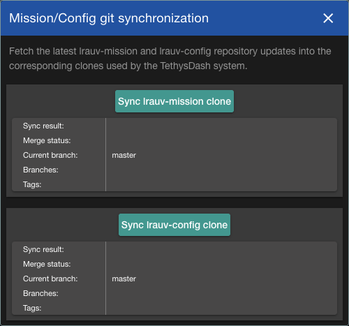
-
When opened, the Sync Mission/Config dialog now immediately shows the checked out branches of the lrauv-mission and lrauv-config clones. The user can then proceed with the syncing per se as needed.
4.97.6 (2025-10-24)
-
Deployment tab: The 'Launch' dialog now shows a warning when the selected date is before the start date of the deployment. It also suggests to first adjust the deployment start date if it is in the future.

4.97.5 (2025-10-24)
-
Mission tab: Improved notification to the user when trying to load a mission script with errors. This will be further improved in the future.

4.97.4 (2025-10-22)
-
Mission tab: Added ability to send mission to a different target vehicle:
- New dropdown button to select the desired vehicle (by default, the one selected in the main tab).
- This and other related buttons are highlighted to bring attention to the fact that the mission will be sent to a different vehicle.
- There's also as "Reset" button to quickly revert to the original vehicle.

Thanks, Steve H., for the reminder as this feature was proposed a while ago.
4.97.3 (2025-10-21)
-
The dropdown for vehicle selection now also reflects any deployments started with a timestamp in the future. Previously, the displayed information was restricted to the current time as upper limit to obtain deployment information.

Note
Playback mode is an exception to this: Such upper limit is as determined by the selected time range.
4.97.2 (2025-10-16)
-
Playback fixes/adjustments:
- Updating the full playback time range (via button recently added) would not consistently update the associated limits to properly reflect the event elapsed fragments in the Log table (e.g., they would be shown as in the future). The range widget itself would also get screwed up. Thanks, Brett H., for reporting the issue.
-
Style adjustments in the playback widget including correct icons for stepping forward/backward and moving to the start/end of the range.
-
Positions loaded/displayed are now only restricted to the selected playback time range, that is, not also by the maximum number of points indicated in the UI settings. (Note: there's actually still a hard limit to avoid overloading the map.)
4.97.1 (2025-09-29)
-
Map tab content display no longer restricted to having vehicles selected. So, other assets, e.g., from the tracking database, can still be displayed.
-
More flexible playback feature: The user can now play back any given time range, that is, not necessarily one associated to a particular vehicle deployment.
-
There's a new button (next to the current-time badge at top of the page) that opens a dialog to directly indicate the time range for the playback. If there's already an ongoing playback, the dialog can be used to update such range.
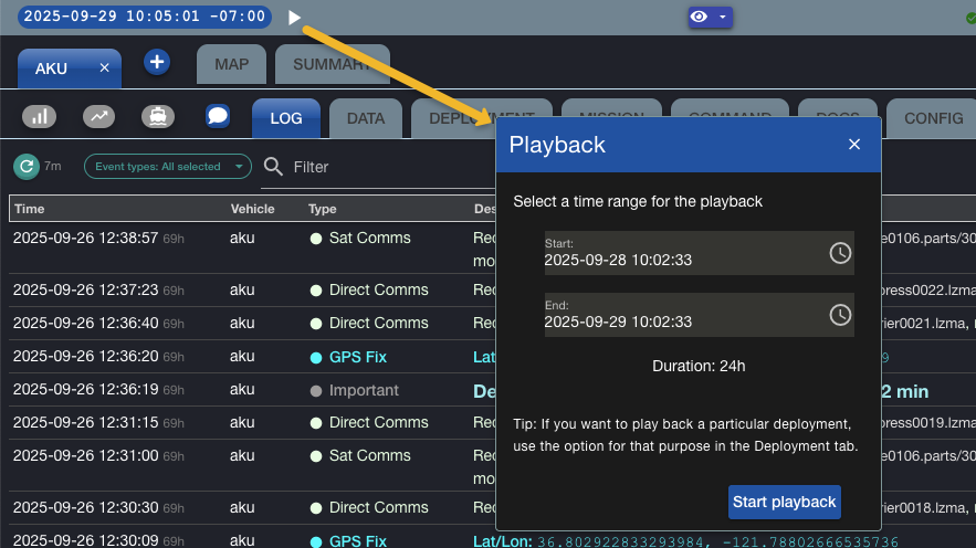
-
The heading of the playback panel itself continues to show either relevant deployment info or the explicit time range itself when the new button is used. Total duration of the range is now also shown.
-
4.97.0 (2025-09-09)
-
When selecting the ESRI Oceans/Labels base layer for the map, a more appropriate mechanism (which involves an ESRI API key) is now used for its display. This also seems to result in a better, more detailed display.
4.96
4.96.72 (2025-09-06)
- The asset tracking feature (introduced in 4.94.0) is now only exposed when relevant configuration is in place. (Not currently the case for WHOI, for example.)
4.96.71 (2025-08-25)
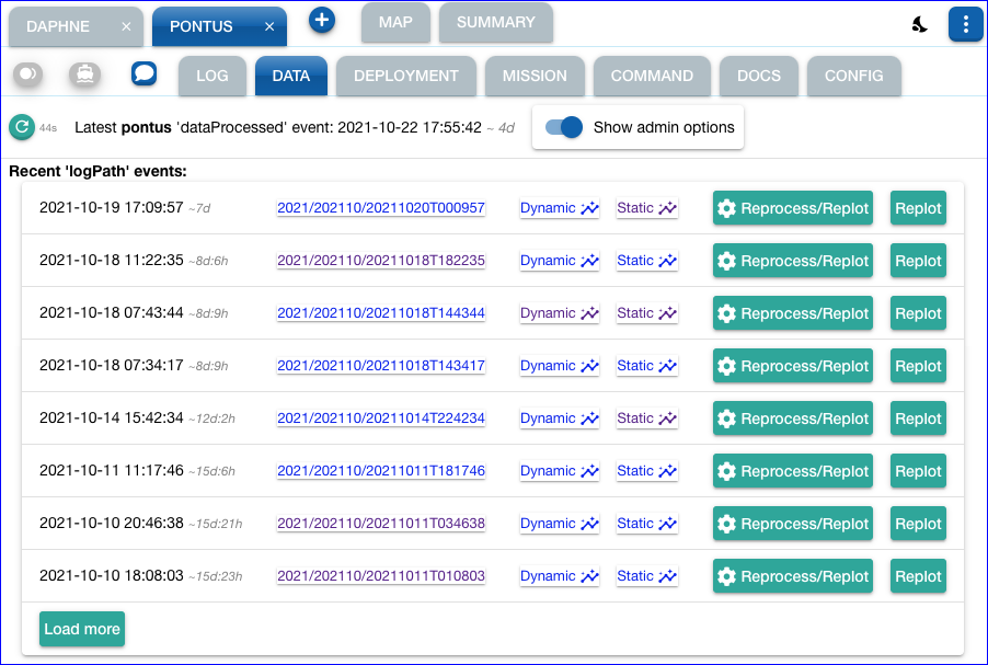
- Fixed bug that would prevent a notification to the user from showing up properly upon possible error in the Reprocess or Replot actions in the Data tab.
- Style: added border to several dropdown selections for better legibility.
4.96.7 (2025-08-21)
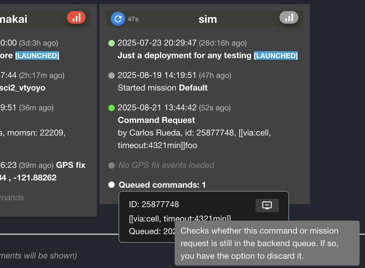
-
Command queue status is now included in the Summary tab for each vehicle. The tooltip shows brief details about the queued command, and includes a button (similar to the one in the main Log tab) to cancel the command if it is still queued.
4.96.62 (2025-07-25)
-
Any commands to overwrite waypoint values (latitudes and/or latitudes) that are issued after the "started mission" event, are now also taken into account to update the information that gets reflected on the dash map. Thanks, Jason A., for bringing up this issue.
Example
In this "sim" example,
Lat3was updated after the mission has started, and then reflected on the map.2025-07-25 09:27:34 ... got command set sci2_flat_and_level.Lat3 36.73985 degree 2025-07-25 09:24:50 ... Started mission sci2_flat_and_level 2025-07-25 09:24:49 ... got command set sci2_flat_and_level.MinAltitude 10 meter 2025-07-25 09:24:49 ... got command set sci2_flat_and_level.ApproachSpeed 1 meter_per_second 2025-07-25 09:24:49 ... got command set sci2_flat_and_level.Lon3 -121.89846 degree 2025-07-25 09:24:49 ... got command set sci2_flat_and_level.Lat3 36.73214 degree 2025-07-25 09:24:49 ... got command set sci2_flat_and_level.Lon2 -121.88404 degree 2025-07-25 09:24:49 ... got command set sci2_flat_and_level.Lat2 36.73985 degree 2025-07-25 09:24:49 ... got command set sci2_flat_and_level.Lon1 -121.87923 degree 2025-07-25 09:24:49 ... got command set sci2_flat_and_level.Lat1 36.72912 degree 2025-07-25 09:24:49 ... got command set sci2_flat_and_level.Depth3 10 meter 2025-07-25 09:24:49 ... got command set sci2_flat_and_level.Depth2 10 meter 2025-07-25 09:24:49 ... got command set sci2_flat_and_level.Depth1 10 meter 2025-07-25 09:24:49 ... got command set sci2_flat_and_level.NeedCommsTime 10 minute 2025-07-25 09:24:49 ... got command set sci2_flat_and_level.MissionTimeout 10 hour 2025-07-25 09:24:49 ... Loaded ./Missions/Science/sci2_flat_and_level.tl id=sci2_flat_and_level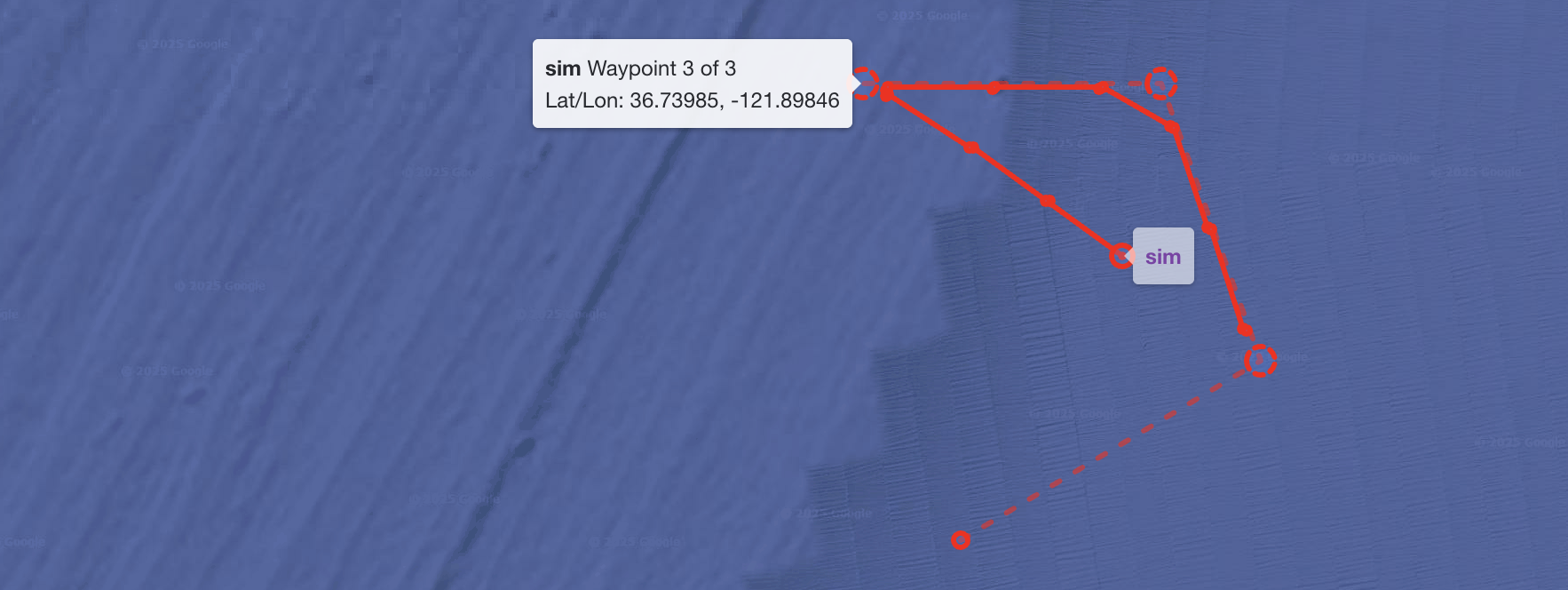
(This adjustment has actually only involved the backend, but mentioned here for visibility.)
4.96.61 (2025-07-23)
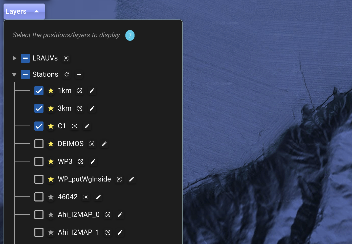
- Changed the handling of the ordering of stations (in the Layers dropdown) as follows:
- No re-ordering by name is done now by dash4, so the ordering will be as captured/adjusted in the backend by power operators, and with newly created stations showing immediately at the end of the list. So, this reverts to the previous behavior before "starring" was introduced.
- However, any starred stations will continue to be displayed at the top.
- Thanks, Quinn S., for the feedback.
- Internal: adjustments in code behind the Command queue status / cancellation dialog.
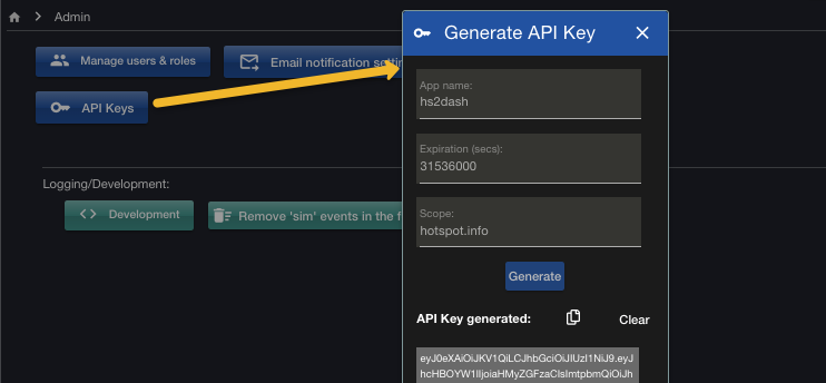
4.96.5 (2025-07-16)
-
Added Admin option to generate API Key.
4.96.4 (2025-07-09)
-
Command queue status / cancellation button also enabled for small screens.
-
Fixed: Re-run button was enabled in the deployment report page.
-
The Command tab now removes any repeated semicolons in the command text, which may have been entered by mistake previously, or just while editing. This cleanup is done when selecting from the dropdowns, and when blurring the field. TODO: more robust and comprehensive validation in general.
4.96.3 (2025-07-09)
- Added ability to cancel a queued command or mission request that has been
issued via
cellorcell-then-sat. (This is a queue the dash backend uses while waiting for the vehicle to fetch the requests via cell connection.)- The new button is included in Log table's Type column
- Opens a dialog that first checks if the request is still queued. If so, the user can then cancel it.
- A
noteevent is generated to indicate the cancellation.
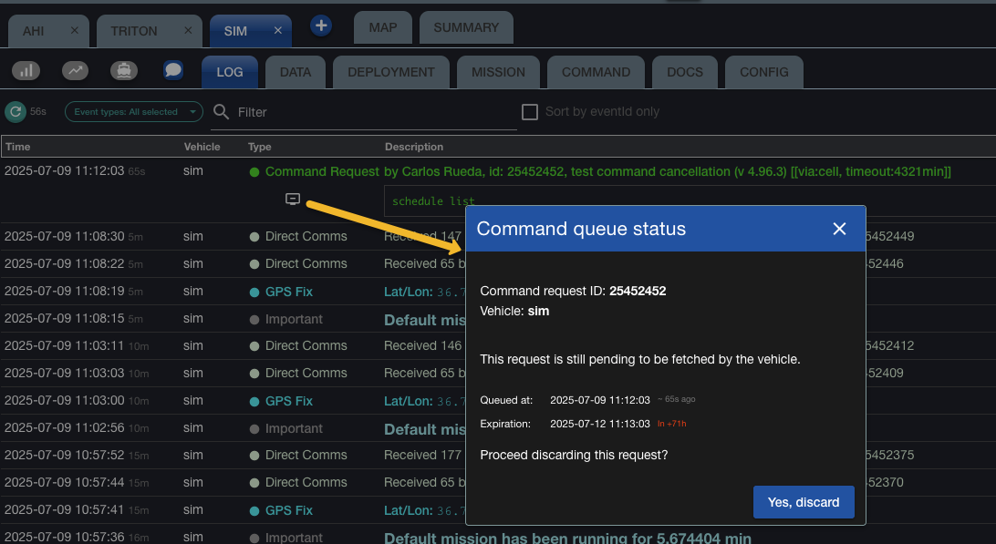
- TODO: Only display the button if the request is still queued.
4.96.1 (2025-06-26)
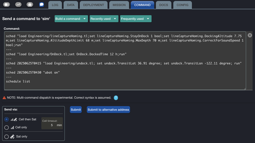
-
⚠️ Experimental: Multi-command dispatch in a single request. Very preliminary version. Status and more details in this section.
-
Style adjustments in the cell connection status elements: better icon, and layout adjustments in tooltip and dialog.
4.95
4.95.0 (2025-06-24)
-
Improved the handling of requests to the backend by adding automatic retry logic for cases where a request might fail due to a stale authentication token. The new logic transparently retries the request once after refreshing the token, reducing the need for manual reloads. This applies to all requests to the backend.
Your help testing this change
- More in concrete, the issue was getting an unexpected failure when trying a request, like sending a command or mission. Reloading the page was an effective but far-from-ideal workaround.
- Please let us know how this new logic works for you, in particular, if you were facing this issue.
Thanks, Steve H., for the great feedback while investigating this issue.
4.94
4.94.83 (2025-06-21)
-
To facilitate issue reporting, the notification dialog displayed when there's an error while trying to submit a command or mission now includes buttons to download and copy-to-clipboard the error details, which you can then include in your issue report. Below is an example with a test error message. Thanks for your help.
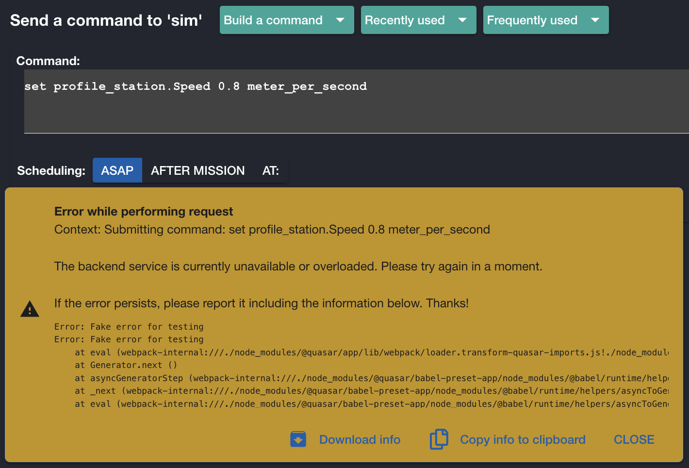
Note
Several other cases of requests to the backend service are not covered with this new dispatch. So, you may still see that unfriendly, "See dev console" message in those cases. 😢
4.94.82 (2025-06-16)
- In the send-via timeout field, the mouse wheel (scroll) gesture is now restricted to change the value only when the pointer is inside the field itself. Thanks, Steve H., for the heads-up.
4.94.81 (2025-06-14)
- More details are now exposed in the notification itself when there's an error trying to submit a command. The exposed information is still of a technical nature, but the user has a chance to capture it when reporting the issue (which hopefully can help with subsequent investigations).
4.94.8 (2025-06-06)
-
The user can now star/unstar stations. Thanks, Monique, for the suggestion!
Important
- The stars are only saved for the user in local storage in the browser.
- Changes across tabs or windows (in the same browser) are not synchronized in the sense of having an immediate visible effect.
- In particular, note that the last-save-wins "rule" applies, so please make sure you only do updates in one tab at a time. If you then switch to other tab or window, use the reload button (next to Stations) to see the latest changes.
The update in this release is as follows:
-
~~The overall list sorting under the Stations section is now by name (case-insensitive). Previously, by order of creation.~~ NOTE: In 4.96.61, this was later reverted to whatever order is defined in the backend. Thanks, Quinn S, for the heads-up!
-
But, any starred stations are always displayed first.
- For each entry, there's a new "star" toggle button. Note that the effect on the list ordering is performed immediately, so scroll as needed to see the effect.
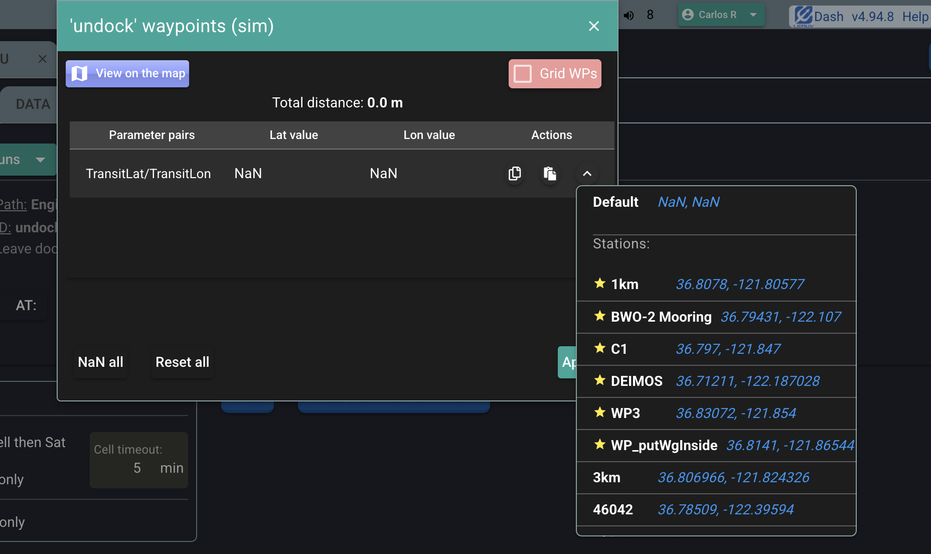
The same sorting is also applied when selecting a station in the Waypoint editor:
4.94.6 (2025-06-04)
-
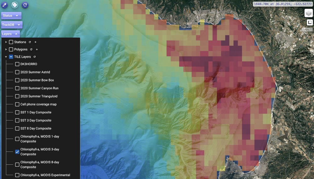
Set some transparency for the display of tile layers on the map. Previously they were displayed with solid colors, not always desirable.
4.94.5 (2025-06-04)
- Config tab:
- The "configSet" category in the table now also considers any configuration overrides,
that is, those ""important" events coming after the most recent
Listing configuration overrides from Data/persisted.cfgevent. WIP. More details in this slack thread.
- The "configSet" category in the table now also considers any configuration overrides,
that is, those ""important" events coming after the most recent
4.94.4 (2025-06-02)
-
Log tab: By default, events are now sorted by both descending
unixTimeand descendingeventId. So, events with the same timestamp are displayed in the (reverse) order they were added to the database. As an example, with the new ordering:
Previously, the order of those events would have been less deterministic, for example, with the
Listing configuration...event appearing in the middle of the actual listing.(Note: There's still the option at the top of the table to sort by
eventIdonly, which allows to see the overall actual sequence of captured events.)
4.94.3 (2025-05-29)
-
Added a transparent background color option to the palette in the document editor. It is now the very first option in the dropdown. Thanks, Steve H., for the suggestion.
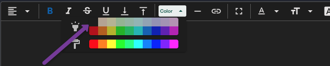
In what cases is this particularly useful? Depending on how initially created/edited, some documents may have explicit solid background colors associated to parts of the document. So, the document may become hard to read depending on the active dark mode. The new option allows to "reset" the current selection to a transparent background for a more legible result, regardless of the active dark mode.
4.94.2 (2025-05-22)
-
Asset tracking fixes/adjustments
- Fix: When there's an active tracking, the dialog now shows the associated parameters.
- Layout/style/responsive-design adjustments
4.94.1 (2025-05-20)
- Allow a zero timeout in the "Send via" section when issuing a command or mission. Previously, a minimum of 1 minute was required. Thanks, Quinn S., for the suggestion.
4.94.0 (2025-05-15)
Two main features introduced in this release: New authentication system and new tracking feature.
Note
If you are still using an older version, please make sure you reload the page (possibly actually requiring a hard reload), given the various underlying settings stored in your browser that are different between the new and the old authentication systems.
-
A new authentication system has been deployed into production, that is, at the usual location https://okeanids.mbari.org/dash4/. Reload the page and verify you see the new version in the upper right corner. This was under testing at a separate location since early 2025. Thanks again to all the users who helped with the testing and provided feedback. Of course, your continued feedback is always welcome.
Documentation is to be updated, but, in short:
-
Signing in. Click the usual button to sign in. This opens a new dialog:
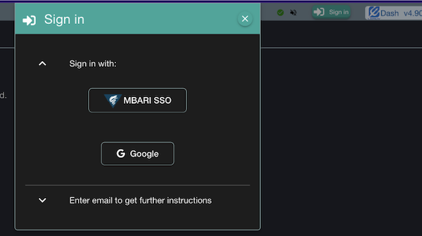
If you are using your MBARI account, click the "MBARI SSO" button.
If you are already signed in to another SSO-enabled MBARI application, you may be signed in automatically. Otherwise, you'll likely be guided through the usual Microsoft/Duo sign-in process, similar to what you may have seen when accessing other MBARI applications.
-
Signing out. Click the usual button to sign out.
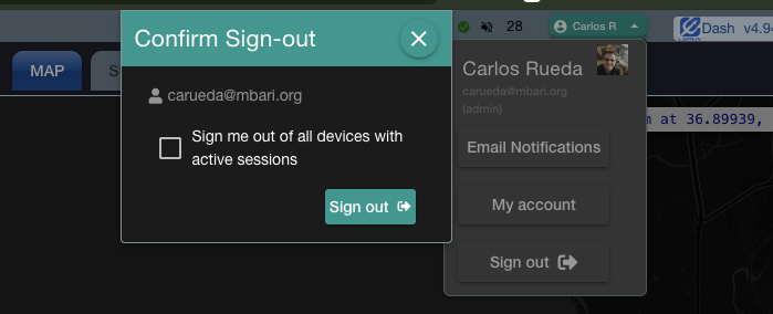
As a new feature, you are given the option to also sign out of any devices (other machines or browsers) where you currently have active Dash4 sessions.
Note
As a backup plan in case of authentication issues (in particular for non-MBARI email accounts), there's an instance with the old authentication system at https://okeanids.mbari.org/dash48/ (note, dash48). This instance will be available for a while, but it is not intended for production use.
-
-
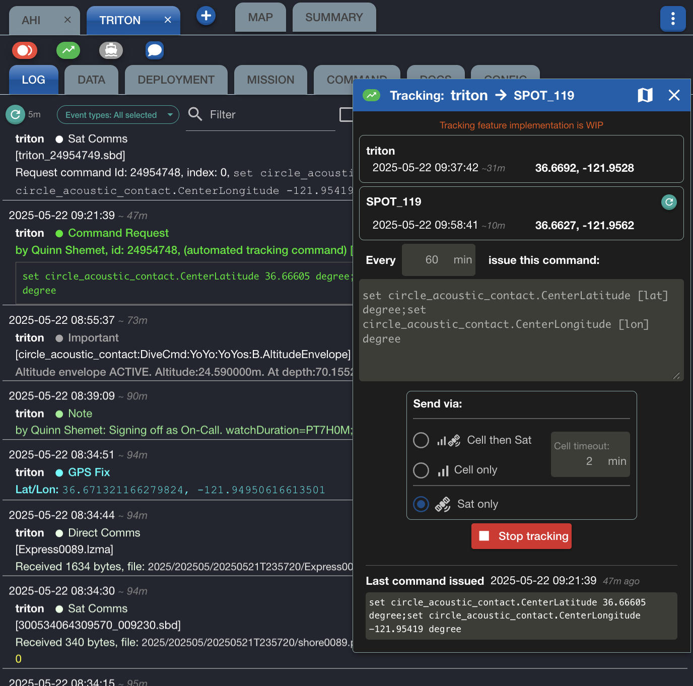
New asset tracking feature. The dash can now automatically issue commands to an LRAUV to track some given asset whose positions are maintained in the MBARI Tracking Database.
This screenshot shows the new button and the dialog that opens up:
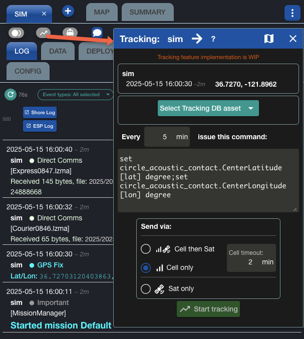
- Select the asset to track from the dropdown.
- Indicate how often to issue the command to the LRAUV.
-
Indicate the command. The text here is a template where
[lat]and[lon]are replaced with the actual position of the asset.To facilitate the editing, newlines are handled as follows when submitting the command:
- Each simple newline is stripped: this avoids unnecessary separate SBDs while keeping the command readable in this dialog.
- Two or more consecutive newlines are replaced with a single newline: this allows to force multiple SBDs if needed.
-
Indicate the via option.
- Click "Start tracking" for the dash backend to perform the automated tracking according to these parameters.
-
This button becomes "Stop tracking", which you (or some other operator) will need to use when done with the tracking.
Note
The dash backend keeps any tracking instances only in memory; so, they will just cease to exist if restarted.
4.82
4.82.3 (2024-12-19)
-
Mission tab: The value cell for a parameter with name containing "depth", and with value greater that the value of the
MaxDepthprimary mission parameter, is highlighted to bring attention to the potential issue. A tooltip shows the respective values.Note
- The depth value is compared to the
MaxDepthvalue without considering the units.
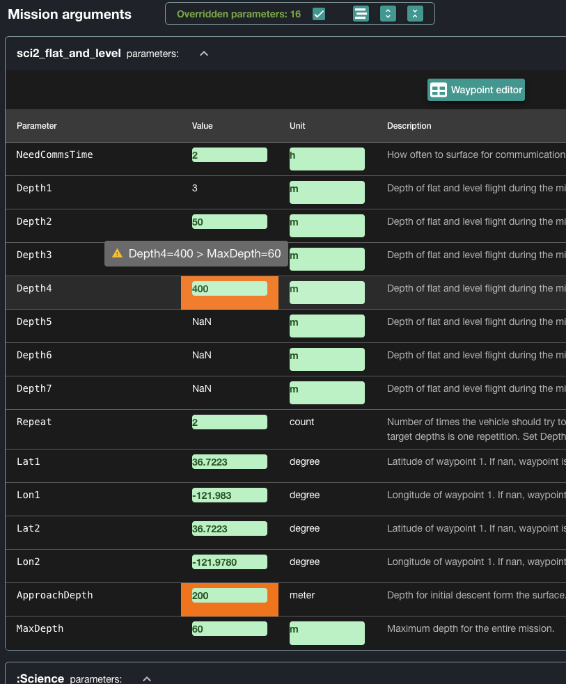
Thanks, Paul R., for the suggestion!
- The depth value is compared to the
4.82.2 (2024-12-06)
- The display of Google base layers on the map got recently broken apparently due to incompatible Google API changes affecting the library used by the dash. This has been fixed.
4.82.1 (2024-11-06)
- Maintenance release.
4.82.0 (2024-10-30)
- Maintenance release, including various style adjustments.
4.81
4.81.2 (2024-10-17)
- Fix to a bug related to resetting string mission parameters. Thanks, Quinn, for reporting and testing.
4.81.1 (2024-10-15)
-
Argos location class accuracy rings are now displayed on the map. For each Argos position, the following are displayed:
- A center point, which displays the usual details via tooltip.
- A circle, whose radius is determined as follows depending on LC value:
- LC=3 Accuracy: Within 150 meters
- LC=2 Accuracy: Within 350 meters
- LC=1 Accuracy: Within 1000 meters
- LC=0 Accuracy: More than 1000 meters -> No circle shown
4.81.0
- The LRAUV entry under the layers dropdown on the map was previously only included depending on availability of recent GPS fixes. Now the LRAUV entry is always included, allowing to display any Argos positions, planned waypoints, emergency positions, etc. Thanks, Brian K., for the heads-up.
- Fixes in the backend related to the Send via options for issuing command or mission. See the backend change log.
- Version bumped to align with that of the backend.
4.70
4.70.5 (2024-08-03)
- Bug fixed in the Send via section under the Command and Mission tabs: Just changing the cell timeout value was also selecting the 'Cell only' option.
-
Styling improvements (for both light and dark modes): In the Mission tab, more prominent options and legible tooltips related to overridden parameters and the expanding/collapsing of sections.
4.70.4 (2024-07-29)
- When opening the submit dialog for a command that was selected from the Recently-used dropdown, the previously used comment is now pre-selected so the user can quickly replace it or edit it as needed. Same behavior when submitting a mission, that is, when starting from the Re-run button, or when selecting from the Recent dropdown.
- For consistency, same cell timeout value by default in both Command and Mission tabs.
(Thanks, Monique, for the great feedback!)
- Minor adjustments/fixes in the Send via section.
4.70.2 (2024-07-09)
Now with only three options in the Send via section under the Command and Mission tabs. Tooltips summarize the effect of each option.
-
Cell then Sat: This is the traditional dispatch, but now with user-given timeout(*). If the command is not fetched within this time by the vehicle, then it is sent via Sat and a
noteevent (with TethysDash as author) is generated with text looking like:Command sent via Sat due to timeout while waiting for 'sim' to fetch it via cell: '...'(*) Note
- A positive timeout must be provided to give the vehicle a chance to fetch the command. (Recall that it is the vehicle that always initiates cell connection.) That is, a zero or very small cell timeout value would most likely have the effect of the command being sent via Sat.
- In the original dispatch there was always a fixed cell timeout (5 minutes).
-
Cell only: Only via cell, and also with required timeout; If the command is not fetched within this time, the command is discarded and a
noteevent is generated with text looking like:Timeout while waiting for 'sim' to fetch command via cell: '...' -
Sat only: Only via email to Iridium or alternative email address; no timeout involved.
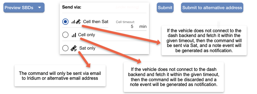
Thanks, Steve H. and Brian K., for the feedback!
4.70.0 (2024-06-19)
Happy Juneteenth!
-
Added "Send only via" options for issuing command or mission. Corresponding backend support added in 4.70.8.
The options:
- No preference: For usual dispatch.
-
Cell: For sending the command via cell connection only. In this case with a required timeout. The command will be discarded if the vehicle does not connect to the dash backend and fetch it within this timeout. A
noteevent will be generated in this case, looking like:Note by TethysDash: Timeout while waiting for 'sim' to fetch command '...' -
Sat (emailing): for sending the command via Iridium only (or to one of the alternative email addresses, if configured).
Many thanks, Steve, for the feedback!
-
For the
AT:option in the command/mission scheduling section, to facilitate verification, there is now a text displaying the time remaining until the given date, relative to the current time. The text looks like:(In 2h:37m from now).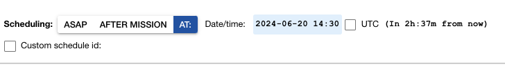
-
Other various adjustments.
4.65
4.65.0 (2024-06-18)
pre-release -- internal under testing
4.64
4.64.2 (2024-06-17)
- Upon selecting the Command tab, everything in it resets to defaults, except the command text itself, which is remembered but only until the command is submitted. In particular, scheduling is reset to AS1AP. Thanks, Monique and Steve, for the heads-up and feedback.
4.64.0 (2024-05-01)
- Scheduling details are now reset upon selecting a mission or when discarding a mission preparation. This has the intended effect of having "ASAP" as the default scheduling option, no matter what the original scheduling was when using the re-run feature or when selecting a mission from the Recent/Frequent Runs dropdowns. Thanks, Monique, for reporting this issue (apparently, a regression).
4.63
4.63.4 (2024-04-29)
- Fix: Re-running a mission (using Re-run button, or when picking from the Recent/frequent Runs dropdowns) did not preserve overrides in inserts. This was actually broken for a long time, coming from rather convoluted/legacy code. Thanks, Monique, for the report!
4.63.3 (2024-04-26)
-
In the Mission tab, some fixes involving overridden boolean parameters:
- Translation of
TrueandFalsevalues, as presented in the UI, to1 booland0 bool, respectively, as accepted by the LRAUV. - Fixed issue with the parsing of the composite command associated with a "re-run" mission
with multiple
set(sub)commands, some of which involving boolean values.
Thanks, Yanwu, for reporting and testing!
- Translation of
4.63.1 (2024-04-22)
- The close button in vehicle coloring dropdown was not having effect: fixed.
4.63.0 (2024-03-27)
- Maintenance release upon the addition of MBARI copyright header added to source files.
4.62
4.62.0 (2024-02-13)
- Fix in listing of mission directory where the "master" branch was always used when no deployment is active, instead of using the currently checked out branch. Thanks, Quinn, for the report.
4.60
4.60.1 (2024-01-16)
-
More complete cell connection status tooltip and improved dialog for legibility.
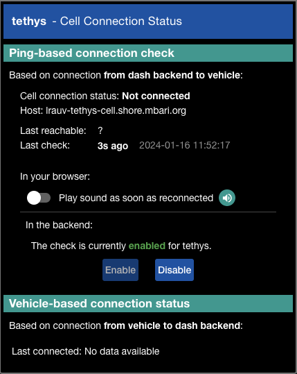
-
Other minor adjustments and internal code cleanup.
4.60.0 (2023-12-21)
- Improved layout of admin pages (including the one with the application logging)
- Improved layout of 'Cell Connection Status' dialog.
- Fixed the individual lat or lon paste issue. The individual paste handling was intended also for the case
of a combined
lat,lontext to populate both fields, but this was causing issues, probably a regression. Such functionality may not even be known to many users, and it is not really intuitive anyway. The simple solution is to remove the paste handling for the individual input fields. NOTE: the button for the combined paste action is still there and functional (as is the copy one). - (Internal) Upgrade of some underlying dependencies.
4.55
4.55.3 (2023-12-14)
- Waypoint editor: The incorrect handling of the clipboard paste action in the longitude field has been fixed, at least partially. This was previously effecting the whole row, but of course, it should only capture the value in the field itself. However, a repeated paste action in this field is not yet properly handled. Thanks, Jared, for reporting.
4.55.2 (2023-11-16)
- In the mission scheduling section, to avoid confusion, all the options are now disabled until a mission is loaded. Thanks, Brent J., for the feedback.
- More adjustments/fixes related to the handling of changed/unchanged boolean parameters.
4.55.0 (2023-11-09)
- A fix related to proper determination of changed boolean parameters in .tl missions when preparing for scheduling. Toggling the checkbox twice (that is, coming back to the original value) would still make the logic consider the parameter as modified thus unnecessarily including the parameter in the issued payload. Thanks, Quinn, for reporting. This happened only with .tl missions, whose parameter description uses all-lowercase literals for boolean values, which, on the other hand, are capitalized in XML missions.
4.54
4.54.2 (2023-10-05)
-
The display of the map that gets exposed under the Data tab has been fixed.
NOTE: The fix for this has actually been in the backend, where such content with the map (and data charts) is generated. More details in the backend change log.
4.54.2 (2023-10-02)
-
The dialog that captures the date and time for mission and command scheduling has been improved. The dialog is now modal when there are modifications (that is, pressing
Escor clicking outside won't close it), takes a bit of less space and is more responsive. The accept and cancel buttons are now at the top right.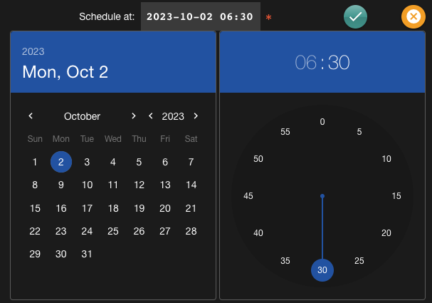
(Thanks, Jared, for the feedback!)
4.53
4.53.3 (2023-09-18)
- The piloting time recorded by PIC and On-Call operators is now reported to admin users as part of the deployment report.
4.53.0 (2023-09-01)
-
General improvements in dispatch of clone synchronization of the lrauv-mission and lrauv-config repositories:
-
Reorganized layout of the Sync M/C dialog, with improved dispatch of each repo
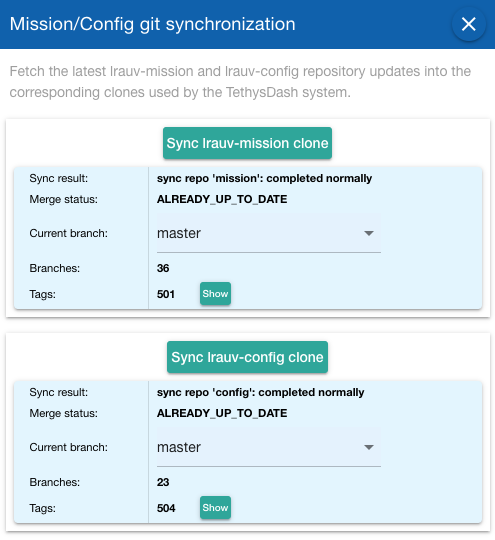
-
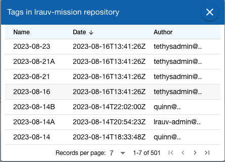
New "Show" button to display the tags associated to the repo upon syncing. By default, the table shows the most recent tag first:
-
See also associated backend changes.
-
4.52
4.52.6 (2023-08-30)
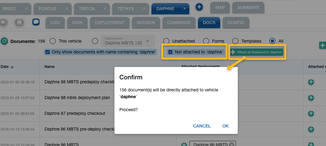
-
Docs tab: All unattached documents can now be attached to the selected vehicle in a single action:
- Along with the usual "Only show documents with name containing <LRAUV>" checkbox, there's now a "Not attached to <LRAUV>" checkbox, which allows to only display documents not attached to the selected vehicle.
- When both checkboxes are selected, a new button becomes available, which allows to attach all displayed documents to the selected vehicle.
4.52.5 (2023-08-30)
- Added a checkbox to the log table so one can sort the events by
eventIdinstead of the usual reported timestamp. SucheventIdis incrementally assigned by the database as events are added, so this should help follow the actual sequence of generated events and even help diagnose possible issues related to timestamping by the vehicle.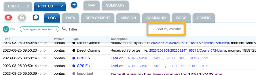
4.52.4 (2023-08-04)
As an ad hoc solution for more accurate depth calculation on non-sea bodies of water (like the Great Lakes), a depth correction mechanism has been implemented:
-
Using the Polygons layer, the user can define a polygon with properties including a depth correction value:
{
  "type": "Feature",
  "properties": {
    "depthCorrection": 175.7,
    "color": "yellow",
    "fillOpacity": 0
  },
  "geometry": {
     "type": "Polygon",
      "coordinates": [...]
  }
}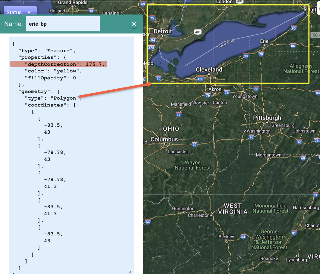
-
Upon fetching the depth from the Elevation API, dash4 checks the currently defined polygons that include a
depthCorrectionproperty to see if the position is within any of them. If so, the associated depth correction is applied.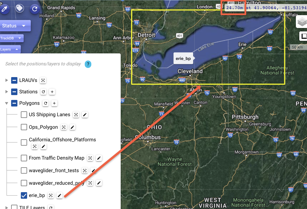
4.52.3 (2023-08-02)
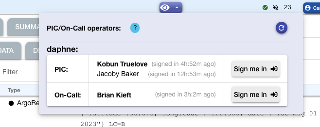
- Operators can now sign off as PIC or On-Call even after deployment has ended.
- Displayed elapsed time while signed-in was incorrect: fixed.
4.52.1 (2023-08-01)
-
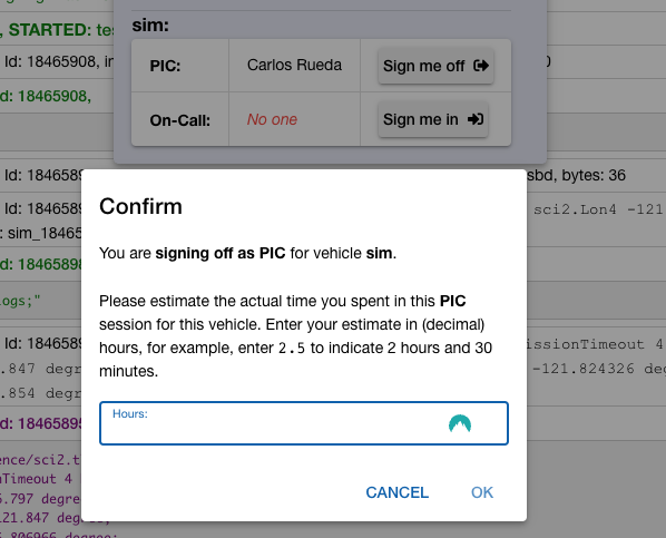
Adjustments to the PIC/On-Call sign-in/off workflow:
-
When signing off, the operator is now asked to enter an estimate of the actual time spent during the watch-standing session.
-
Reverted to the original implementation where multiple operators could be concurrently signed-in as PIC. If someone else has already signed in, the previous person now has a chance to enter the sign-off action and log the time spent.
-
4.51
4.51.0 (2023-07-17)
- The NONE scheduling option has been removed. Per the legacy UI (simply reflected in subsequent UIs), this actually had the same effect as "After mission", but of course this was redundant and confusing.
4.50
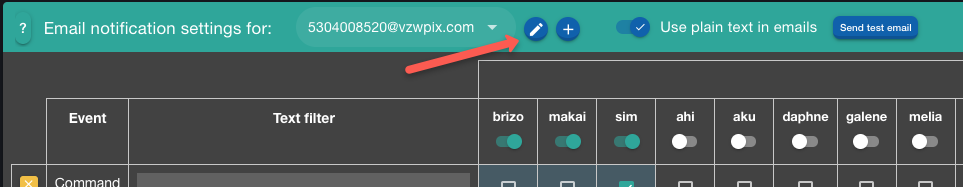
4.50.6 (2023-07-11)
-
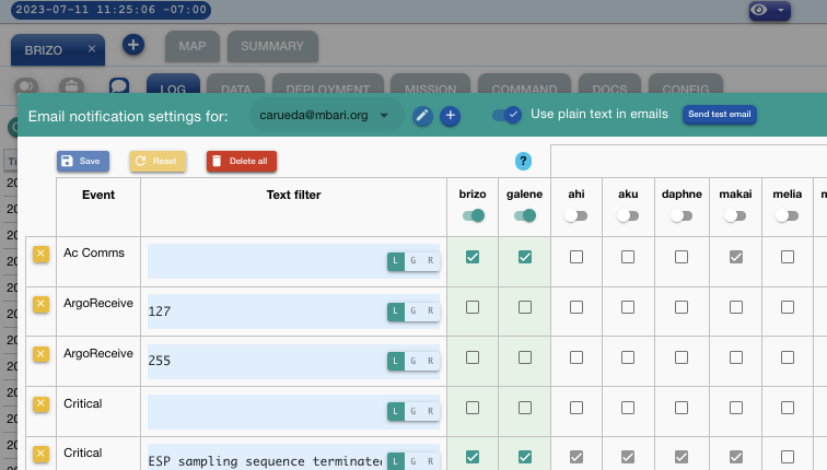
Email notification settings dialog: The Save, Reset, and Delete-All buttons are now located at the top left of the dialog. This avoids the need to scroll to the right, which would sometimes become problematic depending on window size. Thanks, Steve, for the suggestion!
4.50.5 (2023-06-01)
- Internal adjustments per backend 4.50.5.
4.50.1 (2023-05-16)
- Display adjustment for "hs2dash" related events per backend 4.50.1:
the
textfield for the associated sbdReceive and logPath events is now used to capture a "header" in those cases.
4.40
4.40.9 (2023-05-13)
- The "Other" section in the Layers dropdown has been removed. Over time, as we added support for tracking database assets and other map related features, this section turned out to imply a potentially unnecessary "double selection" to see the selected tracking database assets on the map. As part of this change, the associated zoom-to and mouseover functionality (which is common across all layers) were moved to the TrackDB dropdown itself.
4.40.8 (2023-05-04)
-
One can now define circles for the map by using the "stations" feature: Along with the latitude and longitude attributes in the usual definition of a "station," you can include, under the
propertiessection, aradiusMetersattribute with the desired circle radius in meters. Dash will then display this "station" as a circle.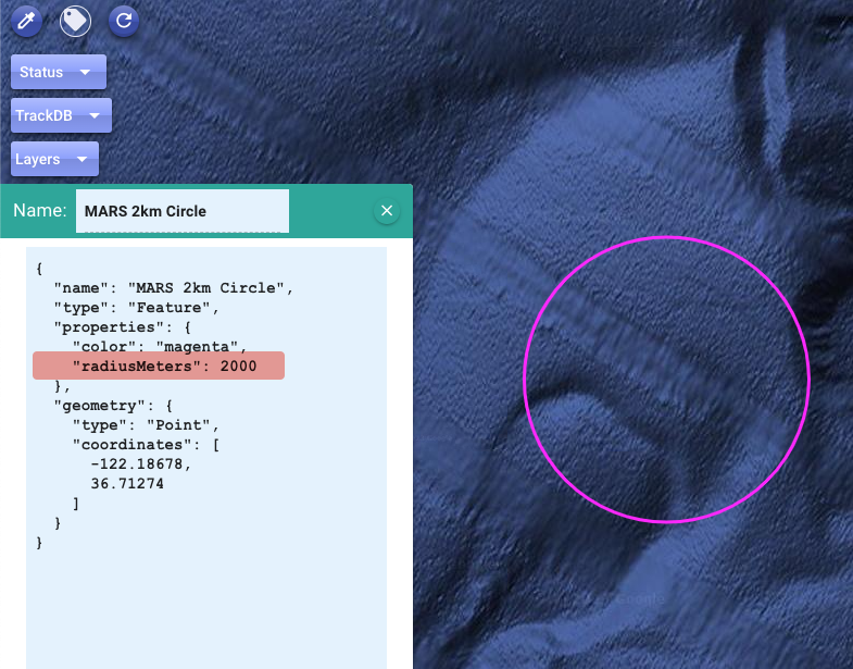
Note: In general, stations are by default displayed with small circle markers, whose
radiusis internally given and measured in pixel (not meter) units. An explicitradiusMetersattribute overrides this default behavior.
4.40.7 (2023-05-01)
-
Waypoint dashed lines are now displayed with some transparency. Thanks, Steve H., for the suggestion.
-
Fix: Map's Status button was included during playback, however, this is not appropriate as the status widgets do not support playback.
- Fix: Waypoint lines were not always showing up on the map. Thanks, Steve H., for reporting.
4.40.6 (2023-04-24)
- Fix a regression in the Deployments report feature: the download options were broken. Thanks, Quinn S., for the heads-up.
4.40.5 (2023-04-21)
-
Dark mode handling adjustments (and for better consistency with the main TethysDash system page):
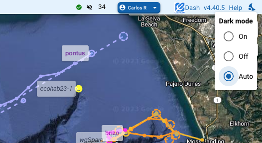
- The Toggle/dropdown is now located in the top right corner, for both desktop and mobile devices.
- Now with "auto" option for synchronizing with OS setting.
4.40.4 (2023-04-20)
- Only internal adjustments, and sync of backend and frontend versions.
4.40.3 (2023-04-15)
-
Layout adjustments and fixes in the 'Status' dropdown area.
4.40.2 (2023-04-11)
- Minor internal adjustments.
4.40.1 (2023-04-10)
- This is an important release of the Dash UI component, but only with internal adjustments, which are mainly related to decoupling its deployment mechanism from that of the main TethysDash system. The new mechanism is also being implemented in other components toward a more flexible, streamlined, and automated release workflow.
4.32
4.32.1 (2023-04-07)
- A fix related to the new vehicle color handling: the original or adjusted colors are now immediately reflected on first load of the webapp.
- Alignment with updated backend.
4.32.0 (2023-04-06)
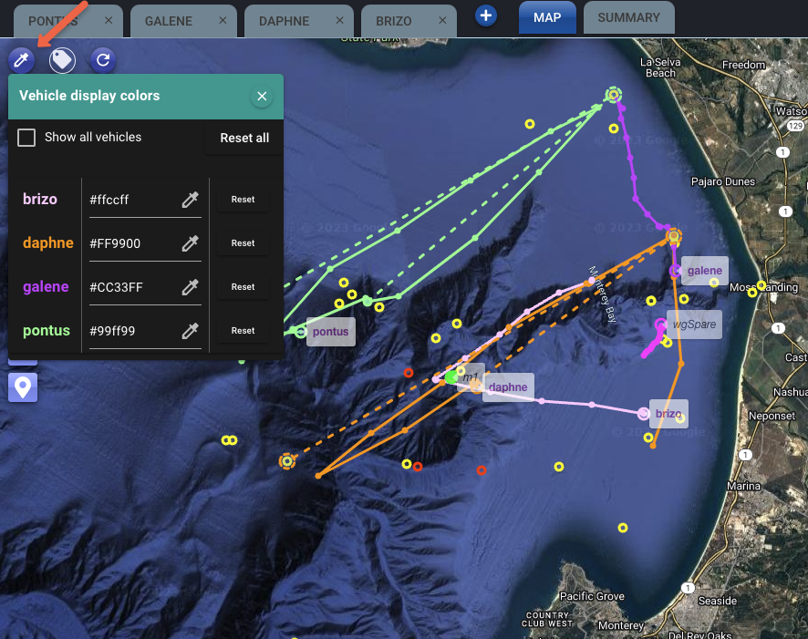
-
The user can now override the LRAUV vehicle colors reported from the backend, for their display on the map. Use the new button on the top left of the map. Any change in color association is immediately saved (in your browser's local storage) but you may need to click the reload button to see the effect right away. Use the Reset buttons to restore the default colors.
-
Bug fix: Non-operator users were not able to edit their notification settings. (Thanks, Ryan G., for reporting.)
4.31
4.31.1 (2023-03-17)
- Open-in-new-window button for the status widget has been moved to avoid obscuring the sparkline.
4.31.0 (2023-03-13)
- Minor styling adjustment for "hotspot" related events as recently implemented in the backend for acoustic comms.
4.30
4.30.2 (2023-02-17)
- No frontend changes; alignment with backend version.
4.30.1 (2023-02-13)
-
Backend: Preliminary implementation of a TethysDash Slack App.
-
Frontend maintenance release.
4.25
4.25.0 (2023-02-08)
- Per relevant adjustment in the backend API, the "Generate DList" button in the Deployment tab is now always available for the deployment, even if its 'launch' or 'recovery' events are not yet recorded.
4.24
4.24.0 (2023-01-26)
- Link from the Mission tab now points to new documentation location: https://docs.mbari.org/lrauvmissions/.
- GMRT base layer added to the list of options.
4.23
4.23.0 (2022-11-21)
- Backend and frontend adjustments regarding configurability related to the URLs of the status widgets.
4.22
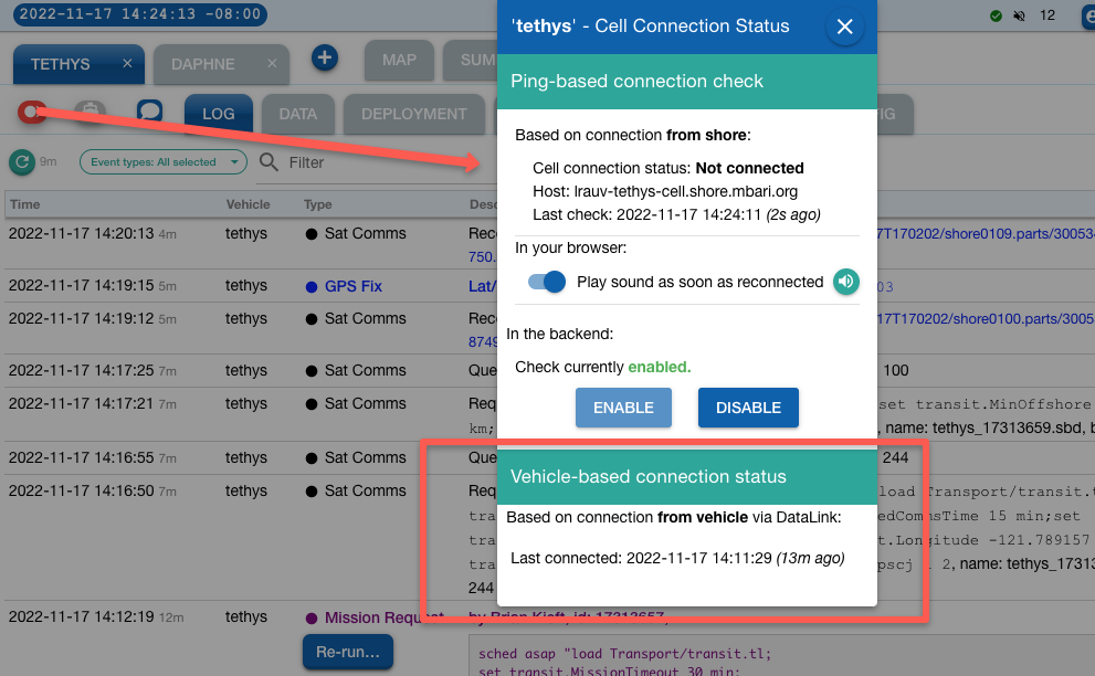
4.22.8 (2022-11-17)
-
More detailed cell connection information, now including last time the vehicle itself has connected via the DataLink endpoint. Both the tooltip and the dialog associated to this feature have been updated.
4.22.5 (2022-11-10)
- Added admin option to delete user accounts.
Thanks Ryan G. (WHOI) for the heads-up and testing.
4.22.4 (2022-11-07)
4.22.1 (2022-10-17)
- Updated documentation link for TethysL missions in the Mission tab: https://docs.mbari.org/tethysdash/dash/tethysl/
4.22.0 (2022-10-07)
4.21
4.21.0 (2022-10-04)
4.21.0 (2022-09-28)
- Proper release with the recent fixes and other maintenance work.
4.20
4.20.0 patched (2022-09-23)
4.20.0 (2022-09-19)
-
Regression fixed in the "Build a command" feature: The UI now handles the new
ARG_LISTargument type that was added on the LRAUV side a few months ago, where several input fields across various possible commands were changed to the new type. WithconfigSetas an example, this now looks like this: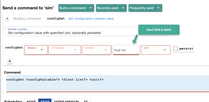
4.12
4.12.8 (2022-09-18)
- Fixed regression that prevented the proper handling of possible mission script
migration (from
.xmlto.tl) when using the "Re-run" button, or when selecting a mission from the "recently used" or "frequently used" dropdowns.
4.12.7 (2022-09-12)
- Fixed issue that prevented the UI from remembering the "Auto reload my last vehicle selection" setting.
4.12.6 (2022-08-31); 4.12.5 (2022-08-22)
4.12.4 (2022-08-11)
- The "Auto reload my last vehicle selection when opening Dash" setting is now pre-enabled by default. You can opt out or adjust this as desired in the General section of the Frontend Settings dialog.
4.12.2 (2022-08-09)
- The heuristic to recognize waypoint parameters in mission scripts has been expanded. These parameters are used by the waypoint editor and when displaying the waypoints during mission execution.
4.12.0 (2022-07-22)
- No visible changes (other than the version number).
- Modifications in the backend.
4.11
4.11.5 (2022-07-18)
- Adjustment in request per update in the backend. If already open, the frontend page will need to be reloaded.
4.11.4 (2022-07-12)
- No visible changes. (additions in the backend.)
4.11.3 (2022-07-01)
-
Given the various mission script migrations from
.xmlto.tlthat are taking place, for the mission re-run feature as well as when selecting a mission from the recent- or frequent-run dropdowns, now Dash displays a confirmation dialog proposing the user to try the alternative mission name: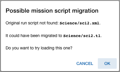
4.11.2 (2022-06-23)
- Only internal changes.
4.11.1 (2022-06-21)
- Fixes related to the display of waypoints for TethysL missions. (As with XML, such display is only available for missions with recognized lat/lon parameters).
- The account button now includes the name of the user (in an abbreviated form).
4.10
4.10.9 (2022-06-13)
- Better alignment with the ODSS in terms of coloring of LRAUV positions on the map.
4.10.8 (2022-06-12)
- Internal: removal of long unneeded "pusher" dependency, both from frontend and backend (also, lots of cleanup in the latter). Our direct websockets based mechanism has proved reliable for a good while already.
4.10.7 (2022-06-06)
- With a fix in the backend, the system now properly handles the desired maximum number of positions to display on the map. (Thanks, Brett, for the report).
4.10.7 (2022-05-27)
- Adjustments in underlying asynchronous message handling.
- A popup notification should now get displayed upon expiration of the session as reported from the backend server. The user will be advised to sign in again.
4.10.6 (2022-05-26)
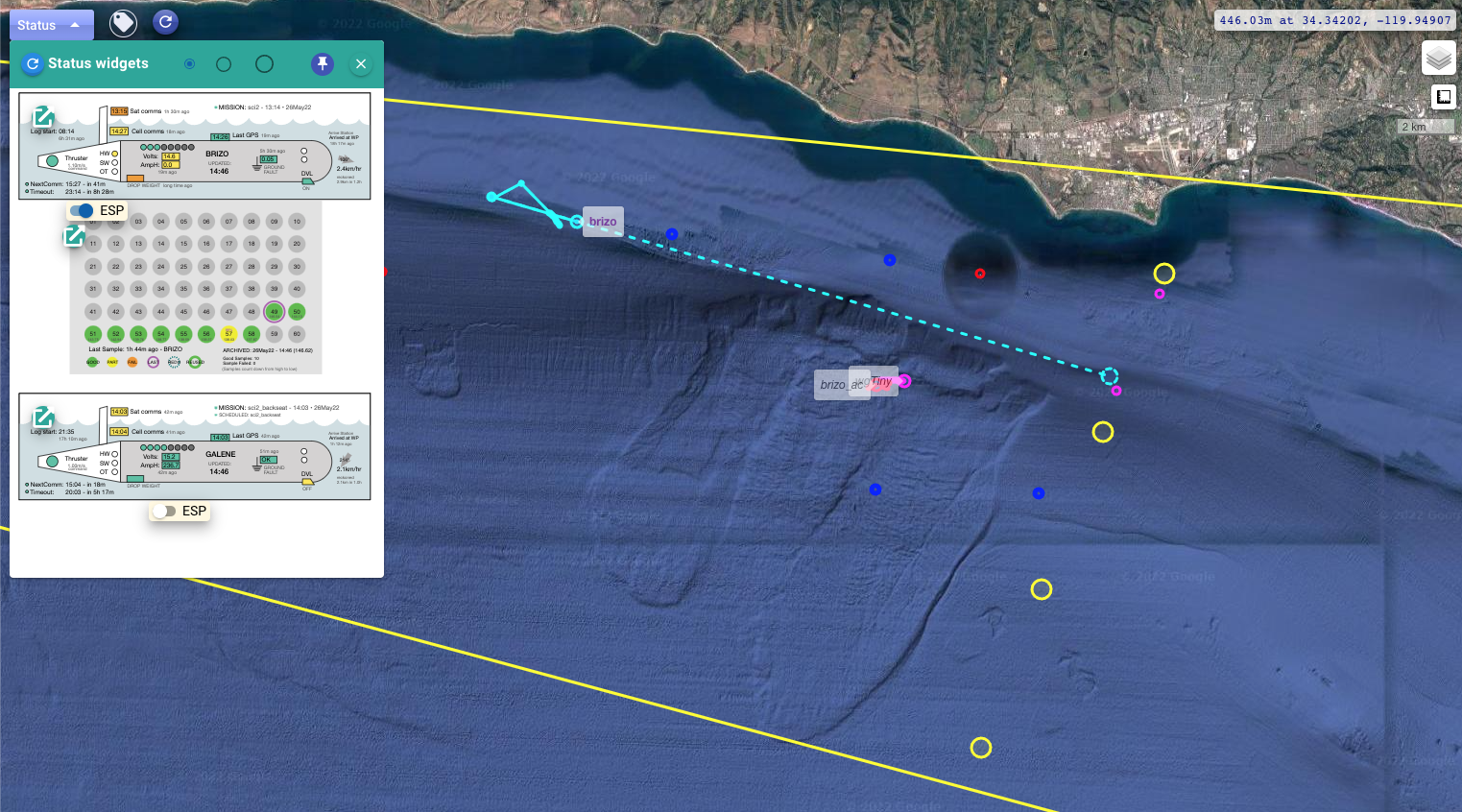
-
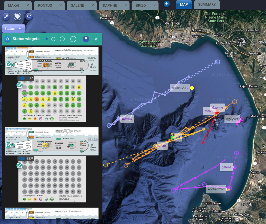
New Status button in the map area to display the LRAUV and ESP status widgets (if available) for the selected vehicles. The expanded area allows for various sizes and can be "pinned" (so it auto-reopens next time the Map tab is selected).
4.10.5 (2022-05-25)
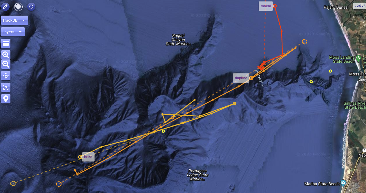
-
Improved visualization of the various positions on the map: hovering your mouse under the "Layers" dropdown now triggers a corresponding highlight on the map for entries that were not considered before, including GPS fixes, waypoints, reached waypoints, emergency positions, Argos positions, and tracking DB assets:
- Circles and connecting lines are drawn for these specific entries, as well as a label for each point indicating corresponding lat/lon.
- For grouping nodes (e.g., a specific LRAUV like "brizo", or the "LRAUVs" root), only circles are drawn (for all associated points).
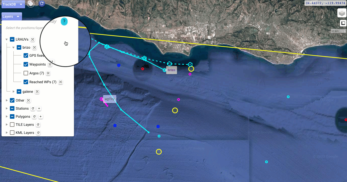
-
Fixed a regression where the waypoint layer was not auto-refreshing when adding/removing an LRAUV.
4.10.4 / 4.10.3 (2022-05-24)
- The vehicle/tab selection is now retained when the user signs in. Thanks for the suggestion, Monique.
- Fixed a bug that prevented the pre-selection of some layers (GPS fixes, waypoints, reached waypoints, emergency locations) from being displayed on the map upon the addition of an LRAUV. This was a regression arising from the recent added feature of saving the layer selection in local storage. (Thanks for reporting, Monique, Brent, Steve.)
4.10.2 (2022-05-23)
-
Improvements under Map > Layers, including:
-
New ability to save a marker as a station: use the new button for this in the marker popup.
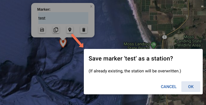
The station will be overwritten if already existing. Note that the marker itself will still remain as such upon saving the location as a station. You can then remove it if you'd like.
-
Section renamed to "My markers" to emphasize they are only stored locally.
- Latitude/longitude info is included again in the tooltip for stations.
- Other adjustments/fixes.
-
4.10.1 / 4.10.0 (2022-05-10)
- Under the "Layers" dropdown in the Map tab, this version brings enhancements related to the definition of stations, and a new similar handling for polygons:
- The layer selection is now saved in the local storage of your browser.
4.9
4.9.8 (2022-04-25)
- Adjustments in backend and docker-based release.
4.9.7 (2022-04-18)
- Adjustments in backend and docker-based release.
4.9.6 (2022-04-04)
-
4.9.6 is a proper release after satisfactory operations with the 4.9.6pre1 prerelease. The key enhancement in this version is that operators can now schedule mission scripts that have been written in TethysL. From the Dash user perspective, the handling of such missions is done exactly as with the usual XML scripts.
👉 More details here. -
A link to mission documentation is now included in the Mission tab.
-
The frontend settings related to the "Current Position Point Cloud" have been moved to the Map section in the dialog (from the Experimental section).
4.9.6pre1 (2022-03-17)
- Preparations for allowing operators to schedule mission scripts that have been written in TethysL.
4.9.52 (2022-02-11)
- Maintenance release.
4.9.51 (2022-02-04)
- Layout adjustments in the email notification settings dialog.
4.9.5 (2022-02-03)
- Debug options to facilitate diagnosing issue with unreported events from the backend depending on selection of event types.
- Fixed elapsed times in the async subscriber dialog during playback mode.
- (Internal) Upgraded underlying framework.
- (Backend) Fixed regression in email notification handling. (Thanks, Brian, for the report.)
4.9.4 (2022-02-01)
- Dash logging enhancements.
4.9.3 / 4.9.2 (2022-01-31)
- Adjustment is scale control.
- Validation of regular expression in the email notification settings.
4.9.1 (2022-01-25)
- The waypoint popup on the map (displayed when clicking one of the planned trajectory lines) now uses a scroll area to avoid the popup to get too tall when there are many waypoints to list.
-
A scale control added to the map.
-
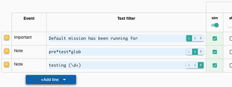
Under testing: In the email notification settings, for every notification line where the text filter is used, operators can now indicate the type of filtering to be applied, with three options:
L: Literal, meaning the usual simple substring checkG: Glob filteringR: Regex filtering
4.9.0 (2022-01-24)
-
Various minor style adjustments in the frontend, including:
- more prominent display of
Default mission has been running for ...events - adjustment in the "Async users/sessions" dialog pagination
- more prominent display of
-
NOTE: More significant changes are in the backend component, regarding the removal of the legacy TethysDash UI, see here.
Note: The legacy TethysDash UI will be shut down on January 21, 2022
Dec 17, 2021: On Oct 19, 2021, we announced a plan to decommission the legacy TethysDash UI in early 2022. The prompt feedback received (thanks again!), has allowed us not only fix some behaviors but also enhance Dash4 in general. These various improvements have already been tested and well received, and we have now determined a concrete shutdown date as indicated above.
4.8
4.8.97 (2022-01-20)
- Backend fix in the logic that handles incoming SBD emails.
Many thanks Ryan G. (WHOI) for your valuable input and testing! - Other adjustments in the backend (in preparation for legacy UI removal).
4.8.93 - 4.8.92 (2022-01-14)
-
Backend fix in the logic that gathers the waypoint information that then gets displayed on the map upon the
Started missionevent. -
New generation of grid mapping waypoints (#96).
See Waypoint Generation.
4.8.7 (2021-12-16)
- Adjustments/fixes and more documentation to recently added features.
4.8.6 (2021-12-15)
-
New features under testing. These can be enabled in the General section of the Frontend Settings:
[ ]Auto reload my last vehicle selection when opening Dash-
[ ]Include advanced modes for event filtering.See Advanced filtering.
(Thanks, Mike G., for the suggestions.)
-
Font size adjustments to address display issues that occur in some Windows/Chrome environments. Thanks, Yanwu, for the heads-up and testing.
4.8.5 (2021-12-14)
-
Improved refresh handling in vehicle selection dropdown: This refresh now reflects changes in the available list of vehicles according to the branch that is currently checked out in the lrauv-config repository clone maintained by the backend.
4.8.4 (2021-12-13)
- Critical security dependency update applied in the backend.
4.8.3 (2021-11-18)
-
Deployment report page now with a
Download as...button to download the generated report in one of the following format options: plain text, HTML, markdown.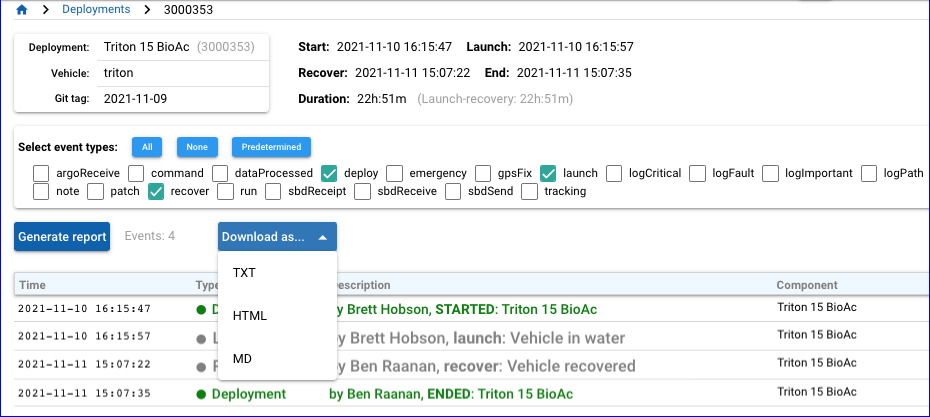
4.8.2 (2021-11-16)
- WIP: New handling of Argos battery low flag indication.
4.8.1 (2021-11-15)
-
Improvements in the functionality related to the Map tab:
- Now used is a new backend mechanism that should make the display of vehicle positions more reliable in general.
- In case of any
emergencyevents, these will now be included on the map. - The "Map" section in the Frontend Settings now includes a 'Maximum time in hours to show positions' parameter, which will be applied along with the usual 'Maximum number of GPS positions to display per vehicle' parameter for actual display of the positions on the map.
- Although all relevant asynchronous events are handled to keep the map up-to-date, there's now also a refresh button to facilitate explicit updates.
Note
Various backend and frontend components were updated as part of the above, so your feedback would be especially welcome here.
4.8.0 / 4.7.9 (2021-11-09)
-
Adjustments in deployment and git tag listings:
- Bug fix: Under the Deployment tab, no more filtering out of any non-standard tag names
when listing deployments. This was inconsistent with the inclusion of such tags in the
selection dropdown when initially starting a deployment.
(Thanks, Mike G., for the heads-up.) - Along with the above, some related improvements:
- The git tag selection dropdown is now sorted by tag date, not by tag name (this mainly because not all tags may follow the "standard" naming convention YYYY-MM-DD).
- As operators are typically only interested in a few of the most recent tags, now a maximum number of tags is displayed in the dropdown, by default 30, but the parameter can be adjusted as desired under the Query section in the Frontend settings.
- Bug fix: Under the Deployment tab, no more filtering out of any non-standard tag names
when listing deployments. This was inconsistent with the inclusion of such tags in the
selection dropdown when initially starting a deployment.
-
Adjustment in the handling of received asynchronous events to better align with the recent event type selection dispatch overhaul: filtering by the selected event types is also applied in this case.
4.7
4.7.8 (2021-11-08)
- Adjustments toward more robust handling of interactions with backend.
4.7.7 (2021-11-03)
- A fix in underlying query related to
Sat Comms Receivedevents. The specific symptom was not getting such events back when they should. (Thanks, Brian, for the heads-up.)
4.7.6 (2021-11-02)
- Internal: new database index to improve performance of certain event type queries.
- Internal: logging adjustments.
- Adjustment in mission selection menu.
- A popup is now used to show details about async sessions.
4.7.5 (2021-10-25)
- More adjustments in the Log tab to closely align with legacy UI in terms of the event type selection dispatch logic. Please see the Log Tab section for details.
4.7.3 (2021-10-22)
- A fix in the "Load more events" functionality:
The event type selection is now used to build the corresponding query to the backend.
Previously, such query was done with default event types
(basically, all except
dataProcessed), while the subsequent filtering, according to the event selection, was completely done in the frontend. (Thanks, Brian and Brett, for the heads-up).
4.7.2 (2021-10-21)
-
Reprocess/Replot options (only for admins) have been added to the Data tab, with same functionality as in the legacy UI. (Thanks, Ben, for the heads-up).
-
Deployment playback enhancements.
- Deployment report adjustments.
- Internal adjustments per enhanced backend APIs.
4.7.0 (2021-10-12)
-
Gathering the waypoint information associated to the last started mission is now done in (and exposed by the API of) the backend. With no more dependency on the query parameters in the frontend settings, this should fix the occasional issue of such waypoints not showing on the map when they should be.*
* This FAQ entry is still relevant.
(#93)
4.6
4.6.9 (2021-10-07)
(With a hotfix in the UI wrt 4.6.8)
-
Internal changes:
- Reflect adjustment in the LRAUV codebase, which now generates
Command.xmlas the command XML file (previouslyCommandLine.xml); - As part of this, note that
CommandExecis now the component name in some events reported from the vehicle (previously,CommandLine). - Various important underlying dependencies updated, including LRAUV and Tomcat.
- Reflect adjustment in the LRAUV codebase, which now generates
-
Externally:
- Fixed issue that prevented the refresh button under the "Build a command" dropdown from working;
- A bit more prominent display of the "Started mission <id>" important event in the Log table.
4.6.5—4.6.7 (2021-08-16)
- More adjustments required in the backend arising from the recent new handling involving the
"sender" email address, initially implemented to circumvent restriction by tmobile
in notifications from
tethysadmin@mbari.org:- Associated with the address for outbound emails, new
replyToconfiguration setting, which allows to indicate the primary address that is regularly monitored. - However, it turns out, the
replyTomechanism is not honored by some external carriers, so, TethysDash now also checks the inbox for the address used for outbound, but in this case only for "request-by-operator" purposes (e.g., a 'note' reply via text to an event notification email). - New configuration setting to explicitly indicate the sender for Iridium purposes.
- Associated with the address for outbound emails, new
4.6.4 (2021-08-10)
- MBARI instance: For event notifications and other emails from the system,
the sender is now
tethysdash@mbari.org(previously,tethysadmin@mbari.org).
-
The "extra" email addresses (used for event notifications purposes) can now be edited and also deleted. When an extra email address is edited, all associated notification settings are transferred to the new address.
Once an extra email address is selected in the notification settings dialog, use the indicated button to edit or delete it:
-
The map includes two additional base layers for selection: a dark layer (CARTO/OpenStreetMap), and an "empty" layer (i.e., no base layer).
4.6.3 (2021-08-03)
- Adjustments in backend logic to reply to text message in case of error in the request. (Thanks, Pat, for the heads-up.)
4.6.2 (2021-07-23)
- As a shortcut, new button in main page to switch light and dark modes. The button is located next to the 3-dot main menu (only for widescreen).
-
Various color adjustments for dark mode, including some for small screens. Thanks for the feedback!
-
Dark mode adjustments also include some under the Docs tab.
Note
Depending on color attributes possibly already incorporated in a document, the rendering of such document in dark mode may not be as readable. You can switch to light mode in those cases.
4.6.0 (2021-07-14)
-
Dark mode has arrived!
The default mode ('Auto') should reflect the "theme" preference in your browser. However, you can explicitly set the mode in the Frontend Settings: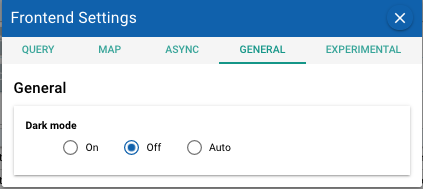
Note
It is possible that not all associated coloring has been adjusted for dark mode in this first version, not to mention that the color selection itself is open to suggestions. As always, your feedback is welcome.
-
MTMSM numbers are now highlighted for certain events in the Log table. This is done for the event types that explicitly capture such piece of information:
sbdReceiptandsbdReceive. Also highlighted arelogImportantevents containingMTMSN=in the description (e.g.,SBD MTMSN=20210714T172908).
4.5
4.5.6 (2021-06-24)
- (Experimental) Operators can now post notes via text messages.
More details in this page. Thanks, Monique, for the suggestion. (td#85)
4.5.5 (2021-06-15)
- New "admin" option to remove events timestamped in the future (for the 'sim' vehicle).
- Data file access has been enabled in the backend, so a file like
shore.csvcan now be retrieved and used by javascript code clients running in the browser itself. (This in particular will facilitate ongoing development of status widgets by UCSC collaborators, as well as some other possible enhancements in the future.) - Other changes in the backend, mainly associated with the service ("odss2dash") that relays platform positions from the Tracking DB, eventually exposed to the Dash UI via websockets.
4.5.3 (2021-06-07)
-
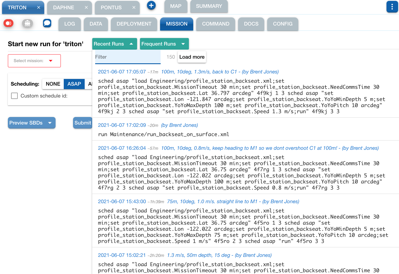
Enhancements in the 'Recent Runs' dropdown under the Mission tab:
- Initial number of loaded 'Mission Request' events has been increased.
- One can now also click a 'Load more' button to load more in increments of 50.
- So, along with the filter one can now really search for pretty much any issued mission while going back in time as much as needed.
- Other associated improvements:
- Event timestamp is now also included in the dropdown list
- The filter is now also applied to the note and timestamp
-
Ability to indicate specific list of vehicles to be exposed.
-
Default map location is no longer hard-coded to Monterey Bay; instead, the whole world gets displayed by default. One can then just click one of the relevant buttons, e.g., "Zoom to all", to restrict the area to actual vehicle positions, or use any other mechanism to change the location and zoom level. Subsequently, as usual, the last selected area and zoom level will continue to be "remembered" in your browser's local storage.
-
Fixed issue about wrong waypoint extraction recently exposed with
front_tracking_2Dfor WHOI. (As is the case with several other missions,front_tracking_2Dis not to be considered for waypoint display given the general limited support for this.) -
Adjusted width of waypoint trajectory details dialog so one doesn't have to do scrolling when on a wide screen.
4.5.2 (2021-06-01)
-
Various adjustments related to vehicle selection, including automatic selection when only one vehicle is available from configuration (which is the current WHOI case).
-
A fix in the websockets endpoint setting when running dockerized system locally.
- Internal adjustments and code cleanup.
4.5.1 (2021-05-21)
-
Fixed issue that prevented the addition of email address for event notification purposes.
-
For operators, the dash can now play a quick sound as soon as cell connection to a vehicle is reestablished. Use the cell connection status dialog to enable this feature:
Note: The currently available sounds in the Dash are from notificationsounds.com, and used under the "Creative Commons Attribution license".
-
Important improvement in the 'reset password' workflow, now more secure and standard: instead of an immediate effect, the request now generates an email with a special, account-specific link to a form where the user can then enter the new password.
4.4
4.4.9 (2021-05-19)
-
Further adjustments in formatting of event notification emails, and a fix to regression related to display of waypoint trajectory. Thanks, Ben for the report and suggestions.
-
Various adjustments and fixes (both UI and backend). Thanks, Ryan G. for the productive sessions and feedback.
4.4.5 (2021-05-18)
-
Adjustments in event notification email formatting (backend 4.1.1). (#176).
-
More legible "Use plain text in emails" toggle in the email notification settings dialog.
-
Various API call adjustments per security enhancements in backend 4.1.0. Make sure you are using this or newer version especially if you need to create an account, sign in, or change your account details or password.
-
Fixed issue in playback mode that prevented the point cloud feature from displaying.
4.4.3 (2021-04-30)
-
This is a significant release, involving both backend and frontend components.
-
The main change in this release is the use of a new underlying mechanism for handling asynchronous messages.
- These changes are mostly internal.
- The selection of this new mechanism is done via configuration in the backend,
so, we could revert to using the traditional mechanism if necessary.
Any change in the selected mechanism should only require:
- (1) A restart of the TethysDash system;
- (2) That users reload the Dash4 page in the browser.
-
Other enhancements/fixes:
-
Missiontab: The unit names associated with any overwritten parameters are now translated to their corresponding abbreviations when constructing the resulting command text to be sent out. (Thanks Ben for the heads-up.)
Using the "Preview SBDs" feature, one can see the effect like this: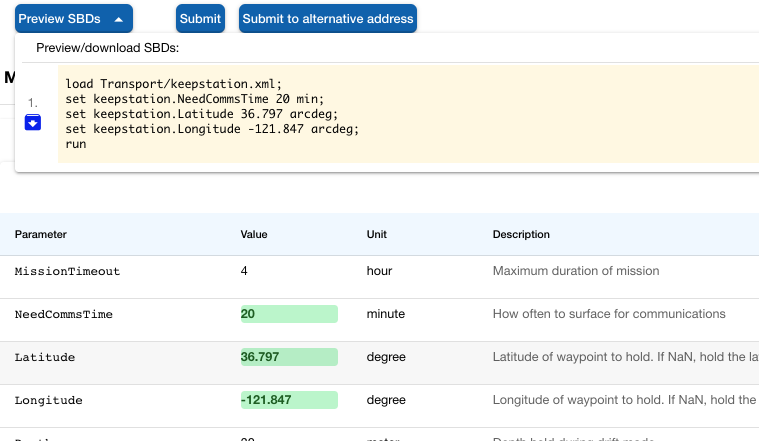
-
In the
Summarytab, the displayed ESP status widget for a vehicle will be the last one "archived" when there is no active deployment; otherwise, just the widget being updated during the ongoing deployment. (Thanks Steve.)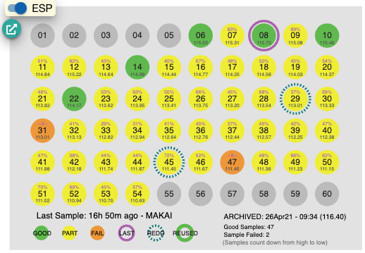
-
In the
Logtab, and located next to the usualshore.loglink, there is now also a link to the "ESP Logs" listing page. (Thanks Brent R. for the suggestion.)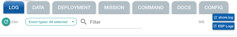
-
PIC: Only the most recent "Signed-in as PIC" operator is shown. (Thanks Ben for the suggestion.) (The On-Call case still may display multiple operators.)
-
Adjustments in admin sections related to email notification settings. (Thanks WHOI for the suggestion.)
-
4.3
4.3.7 (2021-04-08)
-
Adjustments in handling of selected tracking database assets:
- In general, the recent positions for the selected tracking DB assets are now retrieved automatically upon a reload of the Dash page.
- For the "Current Position Point Cloud", there's now a setting (saved in local storage), "Display on the map," to toggle the display of such points.
-
Filtering in the TrackDB selection now also considers the associated abbreviation as captured in the tracking database. E.g., entering
wrin the filter text field should includeWW_205881 (WrWlkr)in the filtered list. When available, this abbreviation is also included in the popup information for the asset on the map.
4.3.6 (2021-03-31)
-
Experimental: new "Current Position Point Cloud" handling for asset positions managed in MBARI's Tracking Database. (Thanks John R. for the suggestion!)
-
Adjustments related to Slack notifications.
-
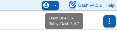
The tooltip for the version text located at the top right of the page will also show the version of the TethysDash backend system.
4.3.4 (2021-03-19)
- Adjustments related to asynchronous notifications for the cell connection status updates. (Initially for the WHOI instance).
4.3.3 (2021-02-18)
-
Issues while preparing mission involving inserts should now be fixed.
(Example:Transport/keepstation_3km.xml.) (#80, #83)- All mission inserts, including all nested ones, should now get exposed in corresponding sections for editing the associated parameters as needed.
- Any overrides for a "Re-run" should also get properly reflected.
-
More visible popup notification upon submitting a mission or a command to the TethysDash backend. (Thanks Steve H. for the suggestion.)
4.3.21 (2021-02-09)
- (Adjustments in the backend regarding the
unserializeprocess.)
4.3.2 (2020-12-16)
-
For vehicle selection, while refreshing the list, only show vehicles with a deployment. (Thanks, Ryan G., for the suggestion).
-
Remove the "status widget" section in "UI Settings -> Experimental." Having the toggle under the Summary tab suffices.
4.3 (2020-12-14)
- Experimental initial use of proper websockets server for asynchronous notifications:
- New Websockets section under UI Settings -> Experimental. Use the toggle there to connect/disconnect to the websocket server.
- Only vehicle cell connection status ("ping") are handled through this mechanism.
4.2
4.2.3 (2020-12-13)
-
Adjustments/fixes in async notification state handling
-
UI settings: Auto-refresh period now with ~0.5 minutes as minimum allowed (this is approximate).
4.2.2 (2020-12-11)
-
Fixed issue that would make command's Send button to stay disabled. (#84)
-
Spaces are now trimmed in all parameter values (including lat/lon) before issuing a mission. This is a general proper handling that also, in particular, should help avoid parsing problems on the vehicle side. (#82)
-
A fix in dispatch of deployment to properly reflect updates upon a launch or recover action. (For example, after a launch, the "Launch" button would still be displayed when coming back to the Deployment tab.)
-
Some minor layout adjustment under the Deployment tab to avoid partially obscuring contents in "DList" sections.
-
There's now a checkbox for inclusion of the ESP status widget for each vehicle in the Summary tab.
4.2.1 (2020-12-07)
-
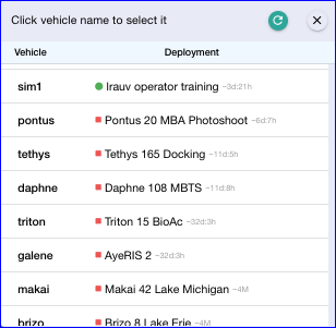
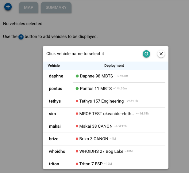
Usability improvement related to the "add vehicle" button (+). This now opens a dialog listing all currently unselected vehicles along with associated deployment status: first, vehicles with an active deployment (with a green circle icon), then those with ended deployments (red icon), and finally those without any registered deployments. On desktop, the tooltip for a line will show more details about the deployment. The dialog will remain open until one is happy adding any vehicles for dispatch in the UI.
(Thanks Monique M. for the suggestion.)
(#79) -
Internal: Configurability related to MBARI's "ODSS-2-Dash" service, which supports the inclusion of tracking DB asset positions on the map.
4.2 (2020-10-30)
-
Implemented solution in the backend to handle improper URL encoding of commands caused by browsers that are not compliant with the HTTP/1.1 specification. Issue manifested by trying to issue a command that includes characters like
[:! onESPclient brent – 'slots [24,26,31] => [:dry,:archive_bac]'Thanks Brent R. for reporting the problem. (#78)
4.1
4.1.4 (2020-10-14)
-
Fixed issue that caused incorrect waypoint dragging on the map (i.e., during mission preparation started from the Mission tab) in the case where some of the other waypoints are set to
NaN. (#77) -
Mission Tab: responsiveness adjustments specially when dealing with a large mission script (e.g.,
Science/isotherm_depth_canon, which has more than 500 parameters!).
4.1.3 (2020-10-12)
- Fixed issue in the "Note" dialog that occasionally made the Send button to remain disabled. (Thanks John R. for reporting.)
4.1.2
- Fixed logic for parsing of waypoints to be displayed on the map.
(As the concrete case recently noted, the pair of parametersCenterLatitudeandCenterLongitudein theScience/circle_acoustic_contactmission was mistakenly extracted as a waypoint. Thanks Yanwu for the heads-up.)
4.1.1 (2020-10-09)
-
The Summary tab now includes Steve's ESP cartridge status widget.
Note: this for now has been included in a rather ad hoc way and only for Makai.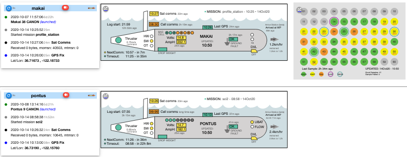
4.1 (2020-10-08)
-
Waypoint editor issues noted today should be fixed.
-
Improved display performance in the "send note" dialog, in particular when also opening the emoji selection 😉.
-
Some various fixes (#74, #73, #27) and upgrades of internal dependencies.
4.0
4.0.1 (2020-10-05)
- Adjustments related to administrative options.
- The main page at https://okeanids.mbari.org/ has been updated and simplified as all functionality is now captured in the Dash UI itself.
- Branding adjustment (primary UI color).
4.0 (2020-10-01)
🙌 First v4 release.
Versions in this new series will be available under the URL path /dash4/,
that is, https://okeanids.mbari.org/dash4/ in the MBARI case.
Note
- The usual
/dash3/URL will continue to be available for a few more weeks. - The traditional TethysDash UI will also continue to be available but in this case with no plans to retire it any time soon.
-
Only the new corresponding implementations are now exposed in the revamped Command and Mission tabs.
-
Performance improvement involving tracking DB position updates on the map.
-
Boat mode improvements.
-
Various usability, style, and layout adjustments.
-
Internal adjustments related to Google APIs.
-
Instead of pointing to the User/Admin webapp (which will also be undergoing some updates), Dash now directly handles creation of user account, update of user account details, as well as the main administration page.
v3
Version 3 release notes have been moved to this page.